1990s Maps of Benewah County, Idaho
Explore 23 historic maps of Benewah County from the 1990s. These maps offer a rare glimpse into what life looked like during the 1990s — showing old roads, neighborhoods, homes, and landmarks that have changed or disappeared over time.
Whether you're researching your family's past, planning a metal detecting trip, or studying how Benewah County's landscape evolved across the 1990s, these high-resolution maps are a powerful tool for exploring the history of this region.
- Focus on a specific era: All maps on this page are from the 1990s, giving you a focused view of this time period.
- See what’s changed: Compare century-old streets, trails, and buildings to today's modern landscape using overlays and satellite layers.
- Research with precision: Use these maps for genealogy, historical research, land use analysis, or educational projects.
- View, download, or print: Maps are fully viewable online in high resolution, and can be downloaded or printed for your own records.
Start exploring Benewah County's history through authentic maps from the 1990s. This is your window into the past.
Benewah County, ID maps
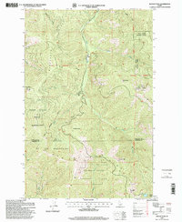
(23)- 1990 Map of Crystal Peak, 1991 Print
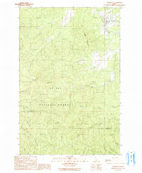
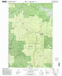
 1990 Crystal Peak1991 Print · USGSShoshone and Benewah counties meet along these high Idaho ridges as they appeared in the early nineties. Researchers can trace the remote network of fire-watch trails leading to Crystal Lookout Tower and summits like Santa Peak and Renfro Peak.
 - 1990 Map of Fernwood, 1991 Print
 1990 Fernwood1991 Print · USGSThe timber country of northern Idaho comes into focus in the early 1990s as the St Maries River winds past the settlement at Fernwood. Local history researchers can trace the county line across Hoodoo Mountain and locate industrial Dredge Tailings and the old Gravel Pit.
 - 1990 Map of Clarkia, 1991 Print
 1990 Clarkia1991 Print · USGSThe Idaho Panhandle's timber and mining country comes to life in the 1990s as the St Maries River carves through these mountains. Genealogists and researchers can trace the settlement of Clarkia, find Jims Spur, or locate the extensive Dredge Tailings along the valley floor.
 - 1990 Map of Santa, 1991 Print
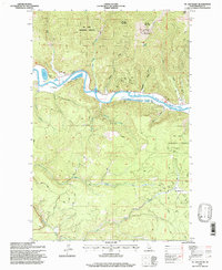
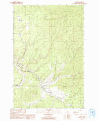 1990 Santa1991 Print · USGSThe St Maries River valley in the early 1990s was a landscape of small riverbank settlements and timbered ridges. Researchers can trace the layout of Santa, find old riverside locations like Mashburn and Renfrew, and locate the Vanderpool Picnic Area Campground.
 - 1994 Map of Mission Mountain, 1997 Print
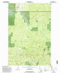
 1994 Mission Mountain1997 Print · USGSThe high ridges of the Idaho Panhandle come into focus during the mid-1990s as this survey traces the border of Latah and Benewah Counties. Researchers can locate the mountain settlement of Mtn Home, family-named peaks like Mission Mountain, and the sprawling Mary Minerva Mc Croskey Memorial State Park.2 unique versions available
 - 1994 Map of Sanders, 1997 Print
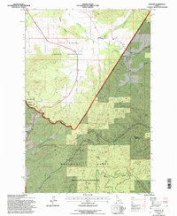 1994 Sanders1997 Print · USGSThe northern Idaho Panhandle comes into focus during the mid-1990s, where reservation lands and national forests converge near the Benewah County line. Researchers can locate the Sanders settlement, the local cemetery, and high points like Prospect Peak and Holaki Knob.2 unique versions available
 - 1994 Map of West Dennis, 1997 Print
 1994 West Dennis1997 Print · USGSThe timbered highlands of Benewah and Latah Counties are documented here during the 1990s as forest management and recreation shaped the region. Genealogists and historians can locate family-named sites like West Dennis and East Dennis or trace landmarks such as Three Tree Butte and the North-South Ski Area.2 unique versions available
 - 1994 Map of Emida, 1997 Print
 1994 Emida1997 Print · USGSEmida and the surrounding Idaho timberlands are documented here in the mid-1990s, where the St. Joe National Forest meets the northern Palouse drainages. Genealogists and local historians can trace the townsite of Emida, the local Cem, and the high ridges of Bald Mountain.
 - 1994 Map of Benewah, 1997 Print
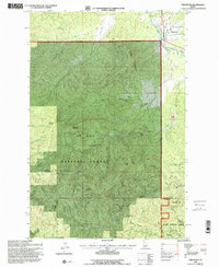
 1994 Benewah1997 Print · USGSThe northern Idaho panhandle during the 1990s shows a landscape of timbered ridges and deep creek valleys within the Coeur D'Alene Indian Reservation. Researchers can locate agricultural landmarks like the Elevators or trace high-country crossings at Windfall Pass and Lolo Pass.
 - 1994 Map of Alder Creek Flats, 1997 Print
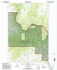
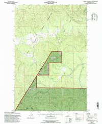 1994 Alder Creek Flats1997 Print · USGSBenewah County’s timberlands and tribal borders are captured here during the mid-1990s. Researchers can trace the junction of the Coeur D'Alene Indian Reservation and St Joe National Forest near Alder Creek.2 unique versions available
 - 1995 Map of Fernwood, 1997 Print
 1995 Fernwood1997 Print · USGSIn the mid-1990s, the timber and mining country of northern Idaho centers on the riverside settlement of Fernwood. Researchers can trace the region's industrial footprint through dredge tailings along Emerald Creek and landmarks like Emerald Butte.2 unique versions available
 - 1995 Map of St. Joe Baldy, 1997 Print
 1995 St. Joe Baldy1997 Print · USGSBenewah County’s timber and rail history is etched into this mid-1990s survey of the forest interior. Genealogists and historians can trace the Old Railroad Grade past the settlement of Omega and up toward the lookout at St Joe Baldy.
 - 1995 Map of Crystal Peak, 1997 Print
 1995 Crystal Peak1997 Print · USGSHigh in the Panhandle mountains during the mid-nineties, this survey captures the timberlands where Benewah and Shoshone counties meet. Researchers can trace the ridgelines from Gold Ridge to Blackwell Hump or locate the site of the Crystal Peak Lookout.
 - 1995 Map of Clarkia, 1997 Print
 1995 Clarkia1997 Print · USGSThe timber and mining country of Shoshone County comes alive in the mid-nineties, centered on the settlement of Clarkia. Researchers can trace the legacy of resource extraction through dredge tailings and Jims Spur along the St Maries River.2 unique versions available
 - 1995 Map of Santa, 1997 Print
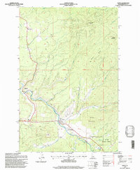 1995 Santa1997 Print · USGSBenewah County in the mid-1990s shows the Maries River valley as a corridor of small settlements and forest industry infrastructure. Researchers can locate Renfrew Cemetery, the riverside community of Mashburn, and the timber heights of Pettis Peak.
 - 1995 Map of St. Joe, 1997 Print
 1995 St. Joe1997 Print · USGSShoshone County’s timber and rail country is captured here during the mid-1990s, centering on the winding St Joe River. Researchers can trace the Old Railroad Grade and locate landmarks like Honey Jones Peak, Urquhart Lake, and the remote St Joe settlement.
 - 1995 Map of Lindstrom Peak, 1998 Print
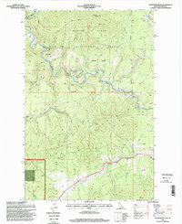 1995 Lindstrom Peak1998 Print · USGSBenewah County's timberlands and river valleys are captured here in the mid-1990s, showing a landscape defined by forest management and remote outposts. Researchers can locate the Hollyood (Site), trace the St Maries River past Rover, and find high-country landmarks like Lindstrom Peak.
 - 1995 Map of St. Maries, 1998 Print
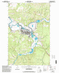 1995 St. Maries1998 Print · USGSSt. Maries and the river forks are captured here in the mid-1990s, showcasing the junction of the timber and rail industries. Trace the path of the Old Grade Railroad past the Sawmill and explore landmarks like Swan Lake and St Maries Peak.
 - 1996 Map of Medimont, 1999 Print
 1996 Medimont1999 Print · USGSThe river and lake systems of the Idaho Panhandle come alive in this mid-nineties survey of the Coeur d'Alene lowlands. Genealogists and historians can trace family roots around Medimont or locate industrial sites like the New Rainbow Mine and Old Rainbow Mine.
 - 1996 Map of Rochat Peak, 1999 Print
 1996 Rochat Peak1999 Print · USGSThe St Joe Mountains of northern Idaho appear here in the 1990s, showing the intersection of tribal lands and national forests. Trace the Old Indian Reservation Boundary and find remote high-country landmarks like Rochat Peak and Crystal Lake.
 - 1996 Map of Black Lake, 1999 Print
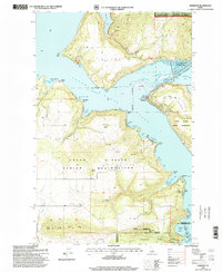
 1996 Black Lake1999 Print · USGSThe Coeur d'Alene River valley in the late nineties is a network of lateral lakes and wetlands. Trace family landmarks and local infrastructure from Kootenai Sch to the shores of Black Lake and Shingle Bay.
 - 1996 Map of Harrison, 1999 Print
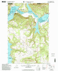
 1996 Harrison1999 Print · USGSThe eastern shores of Coeur d'Alene Lake come alive in the late nineties, showing a landscape defined by the confluence of major rivers and growing lakeside communities. Researchers can trace family sites near Harrison, locate the local Cem, and explore the boundaries of Heyburn State Park.
 - 1996 Map of Twin Crags, 1999 Print
 1996 Twin Crags1999 Print · USGSThe northern Idaho mountains near the border of Kootenai and Shoshone counties appear here in the mid-1990s. Trace the history of mining and forestry through labels like the Palisade Mine, Frost Peak Lookout, and the high ridges of the St Joe Divide.
End of results
Showing maps 1-23 of 23
Top cities of Benewah County
Frequently asked questions
- What are the different types of historical maps available for Benewah County?
- What is the oldest map of Benewah County?
- Where can I purchase historical maps of Benewah County for my home or office?
- Where can I download high-res historical maps of Benewah County?
- Are there historical topographic maps available for Benewah County?
- Is there historical aerial imagery available for Benewah County?
- Where are historical maps of Benewah County sourced from?