1960s Maps of Outlet Bay, Idaho
Explore 2 historic maps of Outlet Bay from the 1960s. These maps offer a rare glimpse into what life looked like during the 1960s — showing old roads, neighborhoods, homes, and landmarks that have changed or disappeared over time.
Whether you're researching your family's past, planning a metal detecting trip, or studying how Outlet Bay's landscape evolved across the 1960s, these high-resolution maps are a powerful tool for exploring the history of this region.
- Focus on a specific era: All maps on this page are from the 1960s, giving you a focused view of this time period.
- See what’s changed: Compare century-old streets, trails, and buildings to today's modern landscape using overlays and satellite layers.
- Research with precision: Use these maps for genealogy, historical research, land use analysis, or educational projects.
- View, download, or print: Maps are fully viewable online in high resolution, and can be downloaded or printed for your own records.
Start exploring Outlet Bay's history through authentic maps from the 1960s. This is your window into the past.
Outlet Bay, ID maps
(2)- 1963 Map of Sandpoint
 1963 Sandpoint1963 Print · USGSNorthern Idaho and eastern Washington are shown in the early sixties as a high-country network of timber, mining, and rail. Genealogists and historians can trace the Great Northern line through Metaline Falls, Bonners Ferry, and past the Finch Mine.
 - 1967 Map of Outlet Bay, 1971 Print
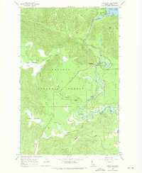 1967 Outlet Bay1971 Print · USGSPriest Lake's southern tip and the upper Priest River are captured in the late sixties, showing a landscape defined by forestry and backcountry water. Researchers can trace historic access points like Dickensheet Junction, Outlet Dam, and the early campgrounds of the Kaniksu National Forest.3 unique versions available
End of results
Showing maps 1-2 of 2
Frequently asked questions
- What are the different types of historical maps available for Outlet Bay?
- What is the oldest map of Outlet Bay?
- Where can I purchase historical maps of Outlet Bay for my home or office?
- Where can I download high-res historical maps of Outlet Bay?
- Are there historical topographic maps available for Outlet Bay?
- Is there historical aerial imagery available for Outlet Bay?
- Where are historical maps of Outlet Bay sourced from?