1990s Maps of Priest River, Idaho
Explore 2 historic maps of Priest River from the 1990s. These maps offer a rare glimpse into what life looked like during the 1990s — showing old roads, neighborhoods, homes, and landmarks that have changed or disappeared over time.
Whether you're researching your family's past, planning a metal detecting trip, or studying how Priest River's landscape evolved across the 1990s, these high-resolution maps are a powerful tool for exploring the history of this region.
- Focus on a specific era: All maps on this page are from the 1990s, giving you a focused view of this time period.
- See what’s changed: Compare century-old streets, trails, and buildings to today's modern landscape using overlays and satellite layers.
- Research with precision: Use these maps for genealogy, historical research, land use analysis, or educational projects.
- View, download, or print: Maps are fully viewable online in high resolution, and can be downloaded or printed for your own records.
Start exploring Priest River's history through authentic maps from the 1990s. This is your window into the past.
Priest River, ID maps
(2)- 1996 Map of Priest River, 1999 Print
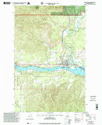 1996 Priest River1999 Print · USGSPriest River and the Pend Oreille River valley are captured in the mid-1990s as the regional timber and recreation economies evolved. Researchers can locate the Bodie Canyon Mine, the Albeni Falls Dam, and civic landmarks like Priest River High School and the local Cem.
 - 1996 Map of Laclede, 1999 Print
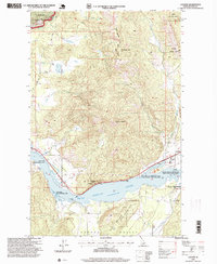 1996 Laclede1999 Print · USGSAlong the shores of the Pend Oreille River in the late nineties, this area was a hub of timber production and wildlife management. Researchers can trace the industrial footprint of the Sawmill in Laclede or find family history at the Seneacquoteen Cemetery.
End of results
Showing maps 1-2 of 2
Top cities near Priest River
Frequently asked questions
- What are the different types of historical maps available for Priest River?
- What is the oldest map of Priest River?
- Where can I purchase historical maps of Priest River for my home or office?
- Where can I download high-res historical maps of Priest River?
- Are there historical topographic maps available for Priest River?
- Is there historical aerial imagery available for Priest River?
- Where are historical maps of Priest River sourced from?