1960s Maps of Newsome, Idaho
Explore 2 historic maps of Newsome from the 1960s. These maps offer a rare glimpse into what life looked like during the 1960s — showing old roads, neighborhoods, homes, and landmarks that have changed or disappeared over time.
Whether you're researching your family's past, planning a metal detecting trip, or studying how Newsome's landscape evolved across the 1960s, these high-resolution maps are a powerful tool for exploring the history of this region.
- Focus on a specific era: All maps on this page are from the 1960s, giving you a focused view of this time period.
- See what’s changed: Compare century-old streets, trails, and buildings to today's modern landscape using overlays and satellite layers.
- Research with precision: Use these maps for genealogy, historical research, land use analysis, or educational projects.
- View, download, or print: Maps are fully viewable online in high resolution, and can be downloaded or printed for your own records.
Start exploring Newsome's history through authentic maps from the 1960s. This is your window into the past.
Newsome, ID maps
(2)- 1960 Map of Elk City
 1960 Elk City1960 Print · USGSThe Central Idaho wilderness and Bitterroot Range are captured here during the peak of mid-century industrial mining. Researchers can trace remote backcountry settlements like Burgdorf and Warren, alongside major mineral sites including the Blackbird Mine and Ima Mine.2 unique versions available
 - 1962 Map of Pilot Knob, 1964 Print
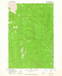 1962 Pilot Knob1964 Print · USGSThe high country of the Nezperce National Forest is captured here in the early sixties, showing a landscape defined by gold mining and timber. Search for traces of the Elk City Stage Road, the Pell Placer Mine, and the Newsome settlement.3 unique versions available
End of results
Showing maps 1-2 of 2
Frequently asked questions
- What are the different types of historical maps available for Newsome?
- What is the oldest map of Newsome?
- Where can I purchase historical maps of Newsome for my home or office?
- Where can I download high-res historical maps of Newsome?
- Are there historical topographic maps available for Newsome?
- Is there historical aerial imagery available for Newsome?
- Where are historical maps of Newsome sourced from?