1950s Maps of Jerome County, Idaho
Explore 7 historic maps of Jerome County from the 1950s. These maps offer a rare glimpse into what life looked like during the 1950s — showing old roads, neighborhoods, homes, and landmarks that have changed or disappeared over time.
Whether you're researching your family's past, planning a metal detecting trip, or studying how Jerome County's landscape evolved across the 1950s, these high-resolution maps are a powerful tool for exploring the history of this region.
- Focus on a specific era: All maps on this page are from the 1950s, giving you a focused view of this time period.
- See what’s changed: Compare century-old streets, trails, and buildings to today's modern landscape using overlays and satellite layers.
- Research with precision: Use these maps for genealogy, historical research, land use analysis, or educational projects.
- View, download, or print: Maps are fully viewable online in high resolution, and can be downloaded or printed for your own records.
Start exploring Jerome County's history through authentic maps from the 1950s. This is your window into the past.
Jerome County, ID maps
(7)- 1950 Map of Filer, 1952 Print
 1950 Filer1952 Print · USGSThe irrigated farmlands of the Magic Valley are captured here during a period of steady post-war growth. Genealogists and local historians can locate early rural landmarks like Maroa School, the IOOF Cem, and the Knull Grange along the Union Pacific tracks.2 unique versions available
 - 1950 Map of Jerome, 1959 Print
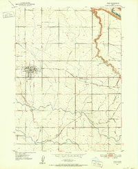
 1950 Jerome1959 Print · USGSJerome and the surrounding Magic Valley countryside are shown here at mid-century, defined by a complex network of irrigation ditches and the deep canyon of the Snake River. Genealogists and local historians can locate early landmarks like Appleton School, Sonnickson Butte, and the Jerome town center.2 unique versions available
 - 1950 Map of Jerome, 1959 Print
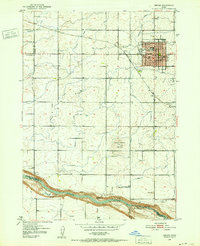
 1950 Jerome1959 Print · USGSThe Magic Valley agricultural landscape is captured here in the 1950s, showing the early growth of Jerome and Filer along the Union Pacific rail lines. Genealogists and local historians can trace rural schools like Cedar Draw School and landmarks including the IOOF Cem and Northview Grange.2 unique versions available
 - 1954 Map of Pocatello, 1963 Print
 1954 Pocatello1963 Print · USGSSoutheast Idaho in the mid-1950s reveals a landscape shaped by massive water reclamation and mountain forests. Researchers can trace the development of the Fort Hall Indian Reservation or locate specific landmarks like the Arbon P O and Emerson School.4 unique versions available
 - 1955 Map of Twin Falls, 1963 Print
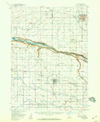
 1955 Twin Falls1963 Print · USGSThe Magic Valley flourished in the mid-1950s as a sophisticated network of irrigation and rail lines connected high-desert outposts. Researchers can trace the engineering of the Milner-Gooding Canal, the remote Murphy Hot Springs, and the Union Pacific rail network.3 unique versions available
 - 1958 Map of Twin Falls
 1958 Twin Falls1958 Print · USGSThe Magic Valley and Snake River Plain are captured here in the late fifties, showcasing a region defined by transformative irrigation projects and desert military ranges. Researchers can trace the Union Pacific rail lines and locate small outlying settlements like Wickahoney, Rogerson, and Hollister.2 unique versions available
 - 1958 Map of Pocatello
 1958 Pocatello1958 Print · USGSSoutheastern Idaho in the late fifties was a landscape of expanding reservoirs and historic trails. Genealogists and historians can trace the Old Oregon Trail, locate the Bannock Creek Indian Day School, and study the many Union Pacific rail sidings.2 unique versions available
End of results
Showing maps 1-7 of 7
Top cities of Jerome County
Frequently asked questions
- What are the different types of historical maps available for Jerome County?
- What is the oldest map of Jerome County?
- Where can I purchase historical maps of Jerome County for my home or office?
- Where can I download high-res historical maps of Jerome County?
- Are there historical topographic maps available for Jerome County?
- Is there historical aerial imagery available for Jerome County?
- Where are historical maps of Jerome County sourced from?