1960s Maps of Bayview, Idaho
Explore 3 historic maps of Bayview from the 1960s. These maps offer a rare glimpse into what life looked like during the 1960s — showing old roads, neighborhoods, homes, and landmarks that have changed or disappeared over time.
Whether you're researching your family's past, planning a metal detecting trip, or studying how Bayview's landscape evolved across the 1960s, these high-resolution maps are a powerful tool for exploring the history of this region.
- Focus on a specific era: All maps on this page are from the 1960s, giving you a focused view of this time period.
- See what’s changed: Compare century-old streets, trails, and buildings to today's modern landscape using overlays and satellite layers.
- Research with precision: Use these maps for genealogy, historical research, land use analysis, or educational projects.
- View, download, or print: Maps are fully viewable online in high resolution, and can be downloaded or printed for your own records.
Start exploring Bayview's history through authentic maps from the 1960s. This is your window into the past.
Bayview, ID maps
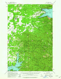
(3)- 1961 Map of Bayview, 1962 Print
 1961 Bayview1962 Print · USGSThe northern tip of Lake Pend Oreille meets the Idaho panhandle's deep forests in the early sixties. Researchers can trace the military history of the Naval Reservation near Bayview or locate remote landmarks like The Old Maids Clearing and Bunco Corners.
 - 1961 Map of Athol, 1963 Print
 1961 Athol1963 Print · USGSNorthern Idaho in the early sixties showcases the intersection of federal forest lands and lakeside settlements. Genealogists and researchers can trace local family landmarks like Mountain View Cem, the Cedar Mtn Sch, and numerous mountain sites including the Shamrock Mine.3 unique versions available
 - 1967 Map of Bayview
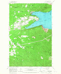 1967 Bayview1967 Print · USGSThe southern tip of Lake Pend Oreille comes alive in the 1960s as a hub for both naval research and public recreation at the edge of the Idaho panhandle. Researchers can trace the military footprint at the Naval Reservation or locate early settlements like Bunco Corners and Lewellen.3 unique versions available
End of results
Showing maps 1-3 of 3
Top cities near Bayview
Frequently asked questions
- What are the different types of historical maps available for Bayview?
- What is the oldest map of Bayview?
- Where can I purchase historical maps of Bayview for my home or office?
- Where can I download high-res historical maps of Bayview?
- Are there historical topographic maps available for Bayview?
- Is there historical aerial imagery available for Bayview?
- Where are historical maps of Bayview sourced from?