1900s (20th Century) Maps of Hayden Lake, Idaho
Explore 10 historic maps of Hayden Lake from the 1900s (20th Century). These maps offer a rare glimpse into what life looked like during the 1900s — showing old roads, neighborhoods, homes, and landmarks that have changed or disappeared over time.
Whether you're researching your family's past, planning a metal detecting trip, or studying how Hayden Lake's landscape evolved across the 1900s, these high-resolution maps are a powerful tool for exploring the history of this region.
- Focus on a specific era: All maps on this page are from the 1900s, giving you a focused view of this time period.
- See what’s changed: Compare century-old streets, trails, and buildings to today's modern landscape using overlays and satellite layers.
- Research with precision: Use these maps for genealogy, historical research, land use analysis, or educational projects.
- View, download, or print: Maps are fully viewable online in high resolution, and can be downloaded or printed for your own records.
Start exploring Hayden Lake's history through authentic maps from the 1900s. This is your window into the past.
Hayden Lake, ID maps
(10)- 1903 Map of Rathdrum
 1903 Rathdrum1903 Print · USGSNorthern Idaho's transition from frontier outposts to a rail-and-timber economy is visible here just after the turn of the century. Researchers can trace the early layout of Rathdrum, locate Fort Sherman, and follow the Leiberg Trail through the mountains.4 unique versions available
 - 1955 Map of Spokane, 1965 Print
 1955 Spokane1965 Print · USGSInland Empire life in the fifties and sixties centers on the growth of Spokane and the heavy mining industry of northern Idaho. Trace mid-century landmarks like Fairchild Air Force Base, the Bunker Hill Mine, and early campuses such as Gonzaga University.2 unique versions available
 - 1958 Map of Spokane
 1958 Spokane1958 Print · USGSThe Inland Empire is shown at a mid-century peak of industrial and military activity, from the rail hubs of Spokane to the deep silver mines of northern Idaho. Researchers can trace the sprawling rail lines of the Union Pacific RR or locate landmarks like Fairchild Air Force Base and the Bunker Hill Smelter & Mine.
 - 1961 Map of Hayden, 1962 Print
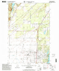
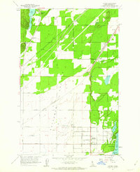 1961 Hayden1962 Print · USGSNorth of Coeur d'Alene in the early sixties, the landscape shows a transition from the industrial Rathdrum Prairie to the recreational shores of Hayden Lake. Researchers can trace family sites near Hayden, locate Pine Grove Cem, or follow the path of the Spokane International railroad.2 unique versions available
 - 1961 Map of Spirit Lake, 1963 Print
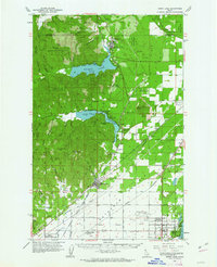 1961 Spirit Lake1963 Print · USGSThe transition from the forested Idaho panhandle to the agricultural Rathdrum Prairie is captured here in the early sixties. Genealogists and rail historians can trace the paths of the Milwaukee Road and locate sites like the Hayden Lake School and Greenwood Cemetery.2 unique versions available
 - 1961 Map of Athol, 1963 Print
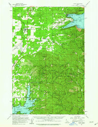 1961 Athol1963 Print · USGSNorthern Idaho in the early sixties showcases the intersection of federal forest lands and lakeside settlements. Genealogists and researchers can trace local family landmarks like Mountain View Cem, the Cedar Mtn Sch, and numerous mountain sites including the Shamrock Mine.3 unique versions available
 - 1961 Map of Hayden Lake, 1963 Print
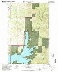
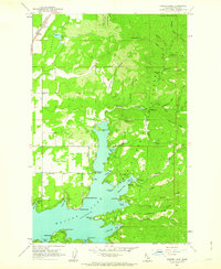 1961 Hayden Lake1963 Print · USGSHayden Lake and the surrounding national forest are captured here in the early sixties, showing a landscape of timber, mining, and growing shoreline recreation. Researchers can find old properties like The Clark House, traces of the Shamrock Mine, and the rail stops at Chilco and Garwood.3 unique versions available
 - 1987 Map of Coeur D'Alene
 1987 Coeur D'Alene1987 Print · USGSNorthern Idaho in the late eighties shows a landscape of deep-water lakes and heavy industry where the timber and mining economies meet growing valley settlements. Genealogists and historians can trace the footprints of the Sunshine Mine, the rail sidings at Corbin Junction, and the historic Old Mission State Park.3 unique versions available
 - 1996 Map of Hayden Lake, 1999 Print
 1996 Hayden Lake1999 Print · USGSHayden Lake and the surrounding Coeur d'Alene National Forest are captured here in the late nineties as recreation and timber lands intersect. Researchers can trace the shoreline's history from Clarksville to Camp Mi-Voden, or locate upland sites like Shamrock Mine.
 - 1996 Map of Hayden, 1999 Print
 1996 Hayden1999 Print · USGSThe Hayden Lake and Rathdrum Prairie region are shown here in the mid-1990s as the area balanced its aviation and agricultural roots with growing residential development. Researchers can locate landmarks like Pine Grove Cemetery, the Hayden Lake Elementary School, and the Coeur d'Alene Air Terminal.
End of results
Showing maps 1-10 of 10
Top cities near Hayden Lake
- Coeur d'Alene historical maps
- Post Falls historical maps
- Hayden historical maps
- Rathdrum historical maps
- Dalton Gardens historical maps
- Spirit Lake historical maps
See more
Frequently asked questions
- What are the different types of historical maps available for Hayden Lake?
- What is the oldest map of Hayden Lake?
- Where can I purchase historical maps of Hayden Lake for my home or office?
- Where can I download high-res historical maps of Hayden Lake?
- Are there historical topographic maps available for Hayden Lake?
- Is there historical aerial imagery available for Hayden Lake?
- Where are historical maps of Hayden Lake sourced from?