1960s Maps of Winchester, Idaho
Explore 2 historic maps of Winchester from the 1960s. These maps offer a rare glimpse into what life looked like during the 1960s — showing old roads, neighborhoods, homes, and landmarks that have changed or disappeared over time.
Whether you're researching your family's past, planning a metal detecting trip, or studying how Winchester's landscape evolved across the 1960s, these high-resolution maps are a powerful tool for exploring the history of this region.
- Focus on a specific era: All maps on this page are from the 1960s, giving you a focused view of this time period.
- See what’s changed: Compare century-old streets, trails, and buildings to today's modern landscape using overlays and satellite layers.
- Research with precision: Use these maps for genealogy, historical research, land use analysis, or educational projects.
- View, download, or print: Maps are fully viewable online in high resolution, and can be downloaded or printed for your own records.
Start exploring Winchester's history through authentic maps from the 1960s. This is your window into the past.
Winchester, ID maps
(2)- 1967 Map of Winchester East, 1971 Print
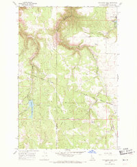
 1967 Winchester East1971 Print · USGSThe Nez Perce reservation highlands of Lewis County come into focus during the late 1960s, showing the early development of Winchester State Park. Local historians can trace the Old Railroad Grade and locate the Morrow Cem and Pine Grove School.2 unique versions available
 - 1968 Map of Winchester West, 1971 Print
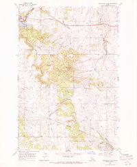
 1968 Winchester West1971 Print · USGSThe plateau around Winchester and the Nez Perce Reservation comes to life in the late 1960s, showing a land of deep canyons and timbered hills. Trace the winding Old Railroad Grade and find water features like Soldiers Meadow Reservoir and Lapwai Lake.
End of results
Showing maps 1-2 of 2
Top cities near Winchester
Frequently asked questions
- What are the different types of historical maps available for Winchester?
- What is the oldest map of Winchester?
- Where can I purchase historical maps of Winchester for my home or office?
- Where can I download high-res historical maps of Winchester?
- Are there historical topographic maps available for Winchester?
- Is there historical aerial imagery available for Winchester?
- Where are historical maps of Winchester sourced from?