1960s Maps of Malad City, Idaho
Explore 2 historic maps of Malad City from the 1960s. These maps offer a rare glimpse into what life looked like during the 1960s — showing old roads, neighborhoods, homes, and landmarks that have changed or disappeared over time.
Whether you're researching your family's past, planning a metal detecting trip, or studying how Malad City's landscape evolved across the 1960s, these high-resolution maps are a powerful tool for exploring the history of this region.
- Focus on a specific era: All maps on this page are from the 1960s, giving you a focused view of this time period.
- See what’s changed: Compare century-old streets, trails, and buildings to today's modern landscape using overlays and satellite layers.
- Research with precision: Use these maps for genealogy, historical research, land use analysis, or educational projects.
- View, download, or print: Maps are fully viewable online in high resolution, and can be downloaded or printed for your own records.
Start exploring Malad City's history through authentic maps from the 1960s. This is your window into the past.
Malad City, ID maps
(2)- 1968 Map of Malad City West, 1971 Print
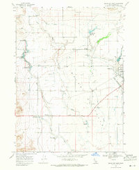 1968 Malad City West1971 Print · USGSOneida County's agricultural heartland is captured here in the late sixties as the irrigation networks of the valley matured. Genealogists and local historians can trace the homesteads around St Johns, the rail corridor of the Union Pacific, and landmarks like Pleasantview Warm Springs.
 - 1968 Map of Malad City East, 1971 Print
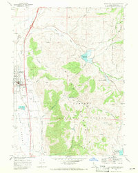 1968 Malad City East1971 Print · USGSOneida County at the end of the 1960s shows a landscape of mountain reservoirs and the critical Union Pacific rail corridor. Trace local landmarks like the Malad City Cem, County Fairgrounds, and the high boundaries of the Caribou National Forest.2 unique versions available
End of results
Showing maps 1-2 of 2
Top cities near Malad City
Top neighborhoods of Malad City
Frequently asked questions
- What are the different types of historical maps available for Malad City?
- What is the oldest map of Malad City?
- Where can I purchase historical maps of Malad City for my home or office?
- Where can I download high-res historical maps of Malad City?
- Are there historical topographic maps available for Malad City?
- Is there historical aerial imagery available for Malad City?
- Where are historical maps of Malad City sourced from?