1900s (20th Century) Maps of Rockland, Idaho
Explore 7 historic maps of Rockland from the 1900s (20th Century). These maps offer a rare glimpse into what life looked like during the 1900s — showing old roads, neighborhoods, homes, and landmarks that have changed or disappeared over time.
Whether you're researching your family's past, planning a metal detecting trip, or studying how Rockland's landscape evolved across the 1900s, these high-resolution maps are a powerful tool for exploring the history of this region.
- Focus on a specific era: All maps on this page are from the 1900s, giving you a focused view of this time period.
- See what’s changed: Compare century-old streets, trails, and buildings to today's modern landscape using overlays and satellite layers.
- Research with precision: Use these maps for genealogy, historical research, land use analysis, or educational projects.
- View, download, or print: Maps are fully viewable online in high resolution, and can be downloaded or printed for your own records.
Start exploring Rockland's history through authentic maps from the 1900s. This is your window into the past.
Rockland, ID maps
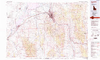
(7)- 1934 Map of Rockland, 1960 Print
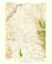 1934 Rockland1960 Print · USGSPower County ranching and transit corridors are frozen in time during the mid-1930s, showing the early infrastructure of the Upper Snake River Valley. Researchers can trace the dual routes of the Oregon Trail and locate isolated schoolhouses like Garris Sch and Central Sch.2 unique versions available
 - 1937 Map of Rockland
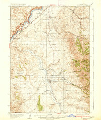 1937 Rockland1937 Print · USGSRockland and the surrounding high-desert canyons are captured here in the mid-1930s as modern highways began to parallel historic western routes. Genealogists and historians can trace the Old Oregon Trail, locate the Cem at Rockland, and find rural schoolhouses like Cold Creek Sch and Garris Sch.2 unique versions available
 - 1954 Map of Pocatello, 1963 Print
 1954 Pocatello1963 Print · USGSSoutheast Idaho in the mid-1950s reveals a landscape shaped by massive water reclamation and mountain forests. Researchers can trace the development of the Fort Hall Indian Reservation or locate specific landmarks like the Arbon P O and Emerson School.4 unique versions available
 - 1958 Map of Pocatello
 1958 Pocatello1958 Print · USGSSoutheastern Idaho in the late fifties was a landscape of expanding reservoirs and historic trails. Genealogists and historians can trace the Old Oregon Trail, locate the Bannock Creek Indian Day School, and study the many Union Pacific rail sidings.2 unique versions available
 - 1971 Map of Rockland East, 1973 Print
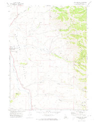 1971 Rockland East1973 Print · USGSPower County, Idaho, in the early 1970s is documented here as a landscape of remote mountain canyons and high-valley ranching. Trace local genealogy and geography through landmarks like the Rockland settlement, the Cemetery, and the prominent Mollys Nipple peak.
 - 1971 Map of Rockland West, 1974 Print
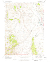 1971 Rockland West1974 Print · USGSThe Rockland valley in the early seventies shows a landscape of high-desert ranching and meticulous water management. Genealogists and historians can trace the irrigation network of West Ditch, the Landing Strip, and landmarks like Snyders Hole.
 - 1984 Map of Pocatello
 1984 Pocatello1984 Print · USGSSoutheast Idaho in the early eighties centers on the industrial and rail corridor between Pocatello and the Snake River. Genealogists and historians can trace routes through the Fort Hall Indian Reservation or locate family sites near American Falls and Lava Hot Springs.2 unique versions available
End of results
Showing maps 1-7 of 7
Top cities near Rockland
Frequently asked questions
- What are the different types of historical maps available for Rockland?
- What is the oldest map of Rockland?
- Where can I purchase historical maps of Rockland for my home or office?
- Where can I download high-res historical maps of Rockland?
- Are there historical topographic maps available for Rockland?
- Is there historical aerial imagery available for Rockland?
- Where are historical maps of Rockland sourced from?