
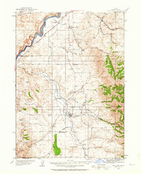
1934 Map of Rockland
USGS Topo · Published 1960About this map
The Oregon Trail and the Old Oregon Trail both course through this 1930s landscape, following the southern banks of the Snake River and cutting through the high country past Massacre Rocks. The valley floor is anchored by Rockland, a central hub for the surrounding ranching and farming communities. A network of rural schools, including Sunbeam Sch, Cold Creek Sch, and Excelsior Sch, reveals the distributed nature of local homesteads during this era. High elevation landmarks like Table Mountain and Mollys Nipple rise above the drainage systems of Rock Creek and its many forks. To the south, the timbered reaches of Minidoka N F provide a stark contrast to the open basin where irrigation features like the East Fork Ditch represent early agricultural engineering efforts near the Cem and Garden Ranch.
Find a feature on this map
40 named features on this map. Tap any name to fly to it.
Don’t see what you’re looking for? This feature index may not catch every label — zoom into the map to look around manually.
Map Details
Editions of this 1934 Rockland Map
2 editions found
Other maps of this area

1934 · American Falls
USGS Topo · 1:62,500

1934 · Michaud
USGS Topo · 1:62,500

1936 · American Falls
USGS Topo · 1:62,500

1937 · Rockland
USGS Topo · 1:62,500

1937 · Michaud
USGS Topo · 1:62,500

1938 · Pauline
USGS Topo · 1:48,000

1944 · Arbon
USGS Topo · 1:62,500

1954 · Pocatello
USGS Topo · 1:250,000

1958 · Pocatello
USGS Topo · 1:250,000

1958 · Sublett
USGS Topo · 1:62,500