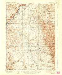
1937 Map of Rockland
USGS Topo · Published 1937About this map
Rockland sits at the heart of the Rockland Valley in this mid-1930s survey, serving as a hub for a dispersed ranching and farming community. The landscape is defined by the canyon-carved banks of the Snake River to the northwest and a network of schools such as Central Sch and Excelsior Sch that supported isolated families. The historic route of the Old Oregon Trail parallels the river, passing notable landmarks like Massacre Rocks and Eagle Rock. The map illustrates a transitional era where the rugged terrain was navigated by both ancient trails and newer infrastructure like State Highway No 30 N. Distinctive features such as Mollys Nipple and Table Mountain rise above the valley, while the Bench Ditch and various springs like Indian Springs highlight the critical role of water management in this high-desert environment.
Find a feature on this map
41 named features on this map. Tap any name to fly to it.
Don’t see what you’re looking for? This feature index may not catch every label — zoom into the map to look around manually.
Map Details
Editions of this 1937 Rockland Map
2 editions found
Other maps of this area

1934 · American Falls
USGS Topo · 1:62,500

1934 · Michaud
USGS Topo · 1:62,500

1934 · Rockland
USGS Topo · 1:62,500

1936 · American Falls
USGS Topo · 1:62,500

1937 · Rockland
USGS Topo · 1:62,500

1937 · Michaud
USGS Topo · 1:62,500

1938 · Pauline
USGS Topo · 1:48,000

1944 · Arbon
USGS Topo · 1:62,500

1954 · Pocatello
USGS Topo · 1:250,000

1958 · Pocatello
USGS Topo · 1:250,000