
1937 Map of Rockland
USGS Topo · Published 1937About this map
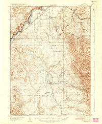
The Old Oregon Trail cuts a diagonal path through the northern reach of this 1930s landscape, tracing a historic route of westward expansion just south of the Snake River. This high-desert region of Power County is defined by the broad Rockland Valley, where the settlement of Rockland serves as a central hub. The distribution of rural education is a striking feature of this era, with several small schoolhouses including Excelsior Sch, Central Sch, and East Fork Sch spaced to serve the ranching families of the canyons and creeks. To the east, the Deep Creek Mountains provide a dramatic vertical boundary, with various named drainages like Water Canyon and Buck Canyon cutting into the massif. This map captures a transition period where early pioneer trails and modern infrastructure, like State Highway No 37, occupy the same rugged Idaho terrain.
Find a feature on this map
42 named features on this map. Tap any name to fly to it.
Don’t see what you’re looking for? This feature index may not catch every label — zoom into the map to look around manually.
Map Details
Editions of this 1937 Rockland Map
2 editions found
Other maps of this area

1934 · American Falls
USGS Topo · 1:62,500

1934 · Michaud
USGS Topo · 1:62,500

1934 · Rockland
USGS Topo · 1:62,500

1936 · American Falls
USGS Topo · 1:62,500

1937 · Michaud
USGS Topo · 1:62,500

1938 · Pauline
USGS Topo · 1:48,000

1944 · Arbon
USGS Topo · 1:62,500

1954 · Pocatello
USGS Topo · 1:250,000

1958 · Pocatello
USGS Topo · 1:250,000

1958 · Sublett
USGS Topo · 1:62,500