
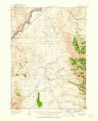
1937 Map of Michaud
USGS Topo · Published 1937About this map
The Fort Hall Indian Reservation dominates the landscape of this mid-1930s survey, illustrating a critical junction of historical and modern transportation in Power County. The Old Oregon Trail runs parallel to the Union Pacific railroad and U S Highway No 30 N, tracing a route past the small settlements of Michaud and Schiller. This corridor reflects the transition from pioneer wagon paths to the burgeoning automobile era, anchored by the Pocatello Airport and its Airway Beacon in the east. Along the northern edge, the expansive American Falls Reservoir meets the Portneuf River, while the interior terrain is marked by significant cultural landmarks such as the Indian Sch and multiple Indian Cem sites. The map captures a moment when traditional land use on the Michaud Flats existed alongside federal infrastructure projects and the rising aviation network of southern Idaho.
Find a feature on this map
33 named features on this map. Tap any name to fly to it.
Don’t see what you’re looking for? This feature index may not catch every label — zoom into the map to look around manually.
Map Details
Editions of this 1937 Michaud Map
This is the sole edition of this map. No revisions or reprints were ever made.
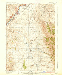
Other maps of this area

1934 · American Falls
USGS Topo · 1:62,500

1934 · Michaud
USGS Topo · 1:62,500
1934 · Rockland
USGS Topo · 1:62,500

1936 · American Falls
USGS Topo · 1:62,500
1937 · Rockland
USGS Topo · 1:62,500

1937 · Pocatello
USGS Topo · 1:48,000
1938 · Pauline
USGS Topo · 1:48,000

1940 · Blackfoot
USGS Topo · 1:62,500

1943 · Blackfoot
USGS Topo · 1:62,500

1944 · Pocatello
USGS Topo · 1:62,500