
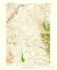
1936 Map of American Falls
USGS Topo · Published 1936About this map
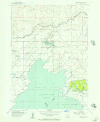
American Falls Reservoir dominates the landscape of this 1930s Idaho survey, created by the U.S. Bureau of Reclamation and the Geological Survey to document the newly harnessed Snake River. The American Falls Dam stands as the focal point of local engineering, supporting a growing regional infrastructure that includes the State Fish Hatchery and the Agricultural Experiment Sta near Aberdeen. Transportation through the high plains is defined by the Union Pacific railroad and the Old Oregon Trail Highway, which trace the southern contours of the water.
Find a feature on this map
35 named features on this map. Tap any name to fly to it.
Don’t see what you’re looking for? This feature index may not catch every label — zoom into the map to look around manually.
Map Details
Editions of this 1936 American Falls Map
This is the sole edition of this map. No revisions or reprints were ever made.
Other maps of this area

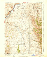
1934 · American Falls
USGS Topo · 1:62,500

1934 · Michaud
USGS Topo · 1:62,500
1934 · Rockland
USGS Topo · 1:62,500
1937 · Rockland
USGS Topo · 1:62,500

1937 · Michaud
USGS Topo · 1:62,500
1938 · Pauline
USGS Topo · 1:48,000
1944 · Arbon
USGS Topo · 1:62,500

1954 · Pocatello
USGS Topo · 1:250,000
1955 · Springfield
USGS Topo · 1:24,000

1955 · Idaho Falls
USGS Topo · 1:250,000