
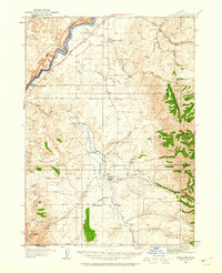
1934 Map of Michaud
USGS Topo · Published 1957About this map
The Fort Hall Indian Reservation dominates this 1934 landscape, where the rising waters of the American Falls Reservoir meet the historic Michaud Flats. The southern portion of the reservoir is well-defined, showing the submerged confluence where the Portneuf River and Bannock Creek once flowed freely. Transportation corridors are a primary focus, featuring the deeply historic Oregon Trail and the industrial backbone of the Union Pacific railroad, which parallel one another through the flatlands. Local life is documented through scattered settlements like Michaud, Schiller, and Bannock, along with essential community sites including an Indian Cem and Indian Sch. Near the eastern boundary, the Pocatello Airport and its Airway Beacon signify the early development of aviation infrastructure in this part of Power County.
Find a feature on this map
33 named features on this map. Tap any name to fly to it.
Don’t see what you’re looking for? This feature index may not catch every label — zoom into the map to look around manually.
Map Details
Editions of this 1934 Michaud Map
This is the sole edition of this map. No revisions or reprints were ever made.
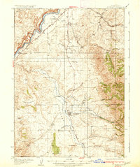
Other maps of this area

1934 · American Falls
USGS Topo · 1:62,500
1934 · Rockland
USGS Topo · 1:62,500

1936 · American Falls
USGS Topo · 1:62,500
1937 · Rockland
USGS Topo · 1:62,500

1937 · Pocatello
USGS Topo · 1:48,000

1937 · Michaud
USGS Topo · 1:62,500
1938 · Pauline
USGS Topo · 1:48,000

1940 · Blackfoot
USGS Topo · 1:62,500

1943 · Blackfoot
USGS Topo · 1:62,500

1944 · Pocatello
USGS Topo · 1:62,500