
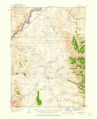
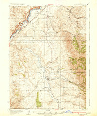
1934 Map of American Falls
USGS Topo · Published 1957About this map
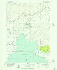
The American Falls Dam anchors this mid-century landscape, holding back the waters of the American Falls Reservoir along the Snake River. This 1930s survey, updated in the 1950s, reveals a high-desert environment transformed by complex irrigation systems, including the High Line Canal and Low Line Canal, which supported the Agricultural Experiment Sta near Aberdeen. The industrial and transport importance of the region is evident through the path of the Union Pacific railroad and the various transmission lines cutting through the terrain.
Find a feature on this map
37 named features on this map. Tap any name to fly to it.
Don’t see what you’re looking for? This feature index may not catch every label — zoom into the map to look around manually.
Map Details
Editions of this 1934 American Falls Map
This is the sole edition of this map. No revisions or reprints were ever made.
Other maps of this area

1934 · Michaud
USGS Topo · 1:62,500
1934 · Rockland
USGS Topo · 1:62,500

1936 · American Falls
USGS Topo · 1:62,500
1937 · Rockland
USGS Topo · 1:62,500

1937 · Michaud
USGS Topo · 1:62,500
1938 · Pauline
USGS Topo · 1:48,000
1944 · Arbon
USGS Topo · 1:62,500

1954 · Pocatello
USGS Topo · 1:250,000
1955 · Springfield
USGS Topo · 1:24,000

1955 · Idaho Falls
USGS Topo · 1:250,000