1950s Maps of Urbandale, Illinois
Explore 5 historic maps of Urbandale from the 1950s. These maps offer a rare glimpse into what life looked like during the 1950s — showing old roads, neighborhoods, homes, and landmarks that have changed or disappeared over time.
Whether you're researching your family's past, planning a metal detecting trip, or studying how Urbandale's landscape evolved across the 1950s, these high-resolution maps are a powerful tool for exploring the history of this region.
- Focus on a specific era: All maps on this page are from the 1950s, giving you a focused view of this time period.
- See what’s changed: Compare century-old streets, trails, and buildings to today's modern landscape using overlays and satellite layers.
- Research with precision: Use these maps for genealogy, historical research, land use analysis, or educational projects.
- View, download, or print: Maps are fully viewable online in high resolution, and can be downloaded or printed for your own records.
Start exploring Urbandale's history through authentic maps from the 1950s. This is your window into the past.
Urbandale, IL maps
(5)- 1950 Map of Paducah
 1950 Paducah1950 Print · USGSThe confluence of the great midwestern rivers defines this mid-century landscape at the intersection of Illinois, Kentucky, and Missouri. Genealogists and historians can trace the rail-and-river economy through the hubs of Paducah, Cairo, and Metropolis or locate family roots near the Wildcat Hills.
 - 1953 Map of Cairo, 1959 Print
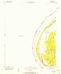
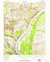 1953 Cairo1959 Print · USGSThe confluence of the Ohio and Mississippi Rivers is captured here in the mid-1950s, showing a landscape defined by floodgates and rail lines. Researchers can trace the layout of Cairo, find family plots at Hazelwood Cem, or locate landmarks like the National Cemetery and Cairo Airport.3 unique versions available
 - 1954 Map of Paducah
 1954 Paducah1954 Print · USGSSouthern Illinois and Western Kentucky intersect at the great river confluences during this mid-century era of rail and river industry. Genealogists and historians can trace family roots and commerce through river towns like Cairo, Metropolis, and Golconda, or along the tracks of the Illinois Central Railroad.2 unique versions available
 - 1954 Map of Cairo, 1955 Print
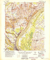
 1954 Cairo1955 Print · USGSThe Kentucky side of the Ohio River in the mid-1950s reveals a landscape defined by the wetlands and sloughs of the BARLOW BOTTOMS. Genealogists and local historians can trace the paths of the GULF CENTRAL MOBILE AND OHIO RAILROAD near East Cairo and the unique topography of Twin Mounds.
 - 1955 Map of Cairo
 1955 Cairo1955 Print · USGSThe confluence of the great rivers at the southern tip of Illinois is captured here in the mid-1950s. Trace the vital rail hubs of Cairo, explore the grounds of the National Cemetery, and locate vanished rural schools like America Sch and Bryan Sch.
End of results
Showing maps 1-5 of 5
Top cities near Urbandale
- Charleston historical maps
- Cairo historical maps
- Tamms historical maps
- La Center historical maps
- Mounds historical maps
- Bardwell historical maps
See more
Frequently asked questions
- What are the different types of historical maps available for Urbandale?
- What is the oldest map of Urbandale?
- Where can I purchase historical maps of Urbandale for my home or office?
- Where can I download high-res historical maps of Urbandale?
- Are there historical topographic maps available for Urbandale?
- Is there historical aerial imagery available for Urbandale?
- Where are historical maps of Urbandale sourced from?