Old Maps of Illinois
Explore 7,879 old maps of Illinois, spanning from 1888 to today. These high-resolution historic maps reveal how streets, neighborhoods, landmarks, and natural features evolved over time — perfect for genealogy, metal detecting, research, and local history exploration.
What you can do with these maps:
- See how Illinois changed over time: Compare historical maps to modern-day views to trace roads, homesites, rail lines & more.
- View detailed metadata: Each map includes creators, publishers, year, scale, and archive source.
- Overlay maps with satellite & LiDAR: Visualize the past alongside modern tools to explore terrain & human change.
- Trusted historical sources: Maps sourced from the USGS, Library of Congress, and other archives.
- Access maps your way: View online, download high-res files, or order prints for personal or research use.
Start exploring old maps of Illinois to uncover forgotten places, hidden landmarks, and the deep history beneath your feet.
Illinois maps
(7,879)- 1888 Map of St. Louis
 1888 St. Louis1888 Print · USGSThe Illinois bottomlands across from St. Louis come alive in the late nineteenth century as a massive railroad hub emerging from the river wetlands. Researchers can trace early rail junctions and settlements like French Village, the ancient Monks Mound, and the industrial waterfronts of Brooklyn and East St Louis.
 - 1889 Map of Chicago
 1889 Chicago1889 Print · USGSChicago in the late Victorian era was a sprawling rail and maritime titan on the shores of Lake Michigan. Genealogists and historians can trace the early urban grid and massive rail yards of the Belt Railroad and Chicago and Northwestern R.R.
 - 1890 Map of Louisiana
 1890 Louisiana1890 Print · USGSUpper Missouri and Illinois river country in the 1890s is captured here at the height of the steam-rail era. Genealogists can trace family roots through old rural outposts like New Harmony, Prairieville, and the transit hub at Bowling Green.5 unique versions available
 - 1890 Map of Des Plaines
 1890 Des Plaines1890 Print · USGSThe Des Plaines valley and southern Cook County are shown here in the late nineteenth century as a hub of canal and rail transit. Genealogists can trace family roots in early settlements like Lemont, Orland, and Mokena or locate vanished stops like Johnston Station.
 - 1891 Map of Davenport
 1891 Davenport1891 Print · USGSIowa's riverfront and rolling prairie townships are captured here during a period of rapid railroad expansion in the late nineteenth century. Trace early land tracts and rail junctions like Eldridge Junction or locate landmarks such as Green Tree Tavern and Maysville.
 - 1891 Map of Chicago
 1891 Chicago1891 Print · USGSChicago was a booming rail and water hub in the late nineteenth century, just before the turn of the century. Trace the intricate network of the Illinois and Michigan Canal and major lines like the Wisconsin Central R.R. and Belt Railroad.
 - 1891 Map of Riverside
 1891 Riverside1891 Print · USGSWest of Chicago in the early nineties, these developing suburbs formed a dense network of rail-side settlements and waterworks. Genealogists can trace early homesteads and vanished landmarks like the County Farm and Mammoth Springs alongside the banks of the Des Plaines River.
 - 1891 Map of Clinton
 1891 Clinton1891 Print · USGSThe Mississippi River corridor thrived as a dual-state rail hub in the 1890s, anchored by the riverfront centers of Clinton and Fulton. Researchers can trace the early tracks of the Chicago and Northwestern RR and locate vanished stops like Almont and Argo.
 - 1892 Map of Morris
 1892 Morris1892 Print · USGSGrundy County thrives as a transportation nexus in the 1890s, where the legendary canal system meets a growing web of iron rails. Trace early industrial footprints in Coal City or follow the path of the Illinois and Michigan Canal through Morris.3 unique versions available
 - 1892 Map of Marseilles
 1892 Marseilles1892 Print · USGSLaSalle County at the close of the nineteenth century showcases a bustling corridor of river commerce and rail expansion. Trace the historic path of the Illinois and Michigan Canal through Marseilles or locate early settlements like Norway and Stavanger.3 unique versions available
 - 1892 Map of Joliet
 1892 Joliet1892 Print · USGSWill County at the end of the nineteenth century was a bustling intersection of canal trade and heavy rail. Genealogists can trace the early streets of Joliet and Lockport or locate long-standing rural landmarks like Caton Farm and Grinton.6 unique versions available
 - 1892 Map of Calumet
 1892 Calumet1892 Print · USGSThe industrial corridor south of Chicago is captured in the late nineteenth century as rail lines and rivers shaped new towns. Genealogists can trace family roots through early settlements like Pullman, Blue Island, and the South Lawn Harvey P.O. at a time of rapid growth.
 - 1892 Map of Goose Lake
 1892 Goose Lake1892 Print · USGSClinton County thrived at the end of the nineteenth century as a hub of river commerce and expanding rail lines. Genealogists and local historians can trace the early development of Camanche on the Mississippi River or the inland rail stops of Charlotte and Low Moor.
 - 1892 Map of Savanna
 1892 Savanna1892 Print · USGSThe upper Mississippi corridor in the late nineteenth century was a bustling hub of river commerce and competing rail lines. Map enthusiasts can trace the old tracks of the Chicago Burlington and Northern Railroad and locate vanished landmarks like Hickory Grove or Idens Lake.8 unique versions available
 - 1892 Map of Wilmington
 1892 Wilmington1892 Print · USGSWill County at the end of the nineteenth century is defined by its strategic river confluences and a rapidly expanding rail network. Genealogists and local historians can trace the early footprints of Wilmington and Braidwood, or find vanished rail stops like Blodget and Drummond.3 unique versions available
 - 1892 Map of Ottawa
 1892 Ottawa1892 Print · USGSLaSalle County, Illinois, is captured here during the late nineteenth-century transition from canal commerce to a dominant rail network. Trace the path of the Illinois and Michigan Canal and find old settlements like Vermillionville, Wedron, and Dayton.9 unique versions available
 - 1892 Map of Leclaire
 1892 Leclaire1892 Print · USGSThe Mississippi River border between Iowa and Illinois comes alive in the 1890s, before modern locks reshaped the shoreline. Genealogists and historians can trace riverside settlements like Leclaire, Port Byron, and the railroad junction at Watertown.
 - 1893 Map of Calumet
 1893 Calumet1893 Print · USGSSouthern Cook County and the Indiana borderlands are captured here during a period of massive rail and industrial growth. Trace the footprints of historic company towns and transit hubs like Pullman, Blue Island, and Hammond before the landscape was fully urbanized.
 - 1893 Map of Riverside
 1893 Riverside1893 Print · USGSWest of Chicago in the 1890s, the landscape was a growing network of rail-centered villages and industrial canals. Genealogists and local historians can trace early property and town layouts in Riverside, Maywood, and the Dunning County Farm alongside the Desplaines River.
 - 1893 Map of Leclaire
 1893 Leclaire1893 Print · USGSThe riverfronts of Scott County and Rock Island County thrived in the late nineteenth century as vital hubs for steamboats and steam rail. Researchers can trace the early grids of Leclaire, Port Byron, and Valley City alongside the sprawling banks of the Mississippi River.4 unique versions available
 - 1893 Map of Brodhead
 1893 Brodhead1893 Print · USGSSouthern Wisconsin is captured in the late nineteenth century as rail lines and river valleys shaped the landscape. Genealogists and historians can trace early village sites like Brodhead, Magnolia Station, and Orford along the Chicago Milwaukee and Saint Paul Railroad.5 unique versions available
 - 1893 Map of Lacon
 1893 Lacon1893 Print · USGSThe Illinois River valley in the early 1890s reveals a landscape of river-port towns and sprawling backwater lakes. Genealogists and local historians can trace the early rail corridors of the Chicago and Alton Railroad and find long-established river settlements like Henry and Sparland.4 unique versions available
 - 1893 Map of Hennepin
 1893 Hennepin1893 Print · USGSBureau County and the Illinois River valley are captured here in the late nineteenth century as the rail network reached its peak. Genealogists and historians can trace the early footprints of Princeton, Bureau Junction, and Tiskilwa along the major trunk lines of the era.2 unique versions available
 - 1893 Map of Metamora
 1893 Metamora1893 Print · USGSWoodford and Marshall counties are shown in the 1890s as the rail networks and river towns of the Illinois valley reached maturity. Researchers can trace the early footprints of Metamora, Washburn, and Rome alongside the path of the Chicago and Alton Railroad.4 unique versions available
 - 1893 Map of Dunlap
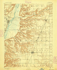
 1893 Dunlap1893 Print · USGSPeoria County and the Illinois River valley are seen here in the 1890s, when the region was a bustling network of rail towns and river bluffs. Genealogists can trace family roots in early settlements like Dunlap, Princeville, and the river community of Mossville.
Showing maps 1-25 of 7,879
Top cities of Illinois
- Chicago historical maps
- Aurora historical maps
- Joliet historical maps
- Naperville historical maps
- Rockford historical maps
- Springfield historical maps
See more
Top counties of Illinois
- Cook County historical maps
- Lake County historical maps
- McHenry County historical maps
- Winnebago County historical maps
- Madison County historical maps
- Saint Clair County historical maps
See more
Frequently asked questions
- What are the different types of historical maps available for Illinois?
- What is the oldest map of Illinois?
- Where can I purchase historical maps of Illinois for my home or office?
- Where can I download high-res historical maps of Illinois?
- Are there historical topographic maps available for Illinois?
- Is there historical aerial imagery available for Illinois?
- Where are historical maps of Illinois sourced from?