1950s Maps of Illinois
Explore 309 historic maps of Illinois from the 1950s. These maps offer a rare glimpse into what life looked like during the 1950s — showing old roads, neighborhoods, homes, and landmarks that have changed or disappeared over time.
Whether you're researching your family's past, planning a metal detecting trip, or studying how Illinois's landscape evolved across the 1950s, these high-resolution maps are a powerful tool for exploring the history of this region.
- Focus on a specific era: All maps on this page are from the 1950s, giving you a focused view of this time period.
- See what’s changed: Compare century-old streets, trails, and buildings to today's modern landscape using overlays and satellite layers.
- Research with precision: Use these maps for genealogy, historical research, land use analysis, or educational projects.
- View, download, or print: Maps are fully viewable online in high resolution, and can be downloaded or printed for your own records.
Start exploring Illinois's history through authentic maps from the 1950s. This is your window into the past.
Illinois maps
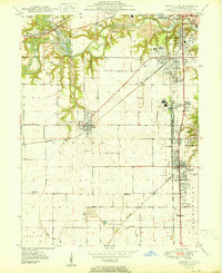
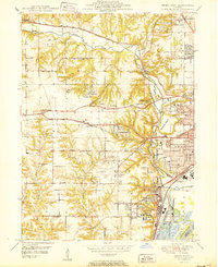
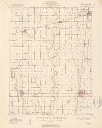
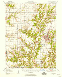
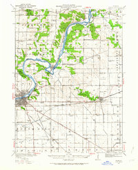
(309)- 1950 Map of Sandwich
 1950 Sandwich1950 Print · USGSNorthern Illinois prairie and river valleys come alive in the mid-century, following the rail lines of the Chicago Burlington and Quincy. Trace family roots at the Sandwich Fair Grounds or local landmarks like Maramech Hill and State Boys Training School.2 unique versions available
 - 1950 Map of Aurora North
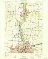 1950 Aurora North1950 Print · USGSKane County's river-driven industrial corridor is in full mid-century expansion between Batavia and Aurora. Genealogists and researchers can trace local institutions and schools such as Mooseheart, Aurora College, and Neilson Grove Sch.
 - 1950 Map of Paducah
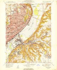
 1950 Paducah1950 Print · USGSThe confluence of the great midwestern rivers defines this mid-century landscape at the intersection of Illinois, Kentucky, and Missouri. Genealogists and historians can trace the rail-and-river economy through the hubs of Paducah, Cairo, and Metropolis or locate family roots near the Wildcat Hills.
 - 1950 Map of Dwight
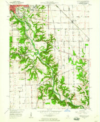
 1950 Dwight1950 Print · USGSNortheastern Illinois at mid-century shows a landscape shaped by coal mining and a dense network of rural school districts. Genealogists can trace family footprints through dozens of local landmarks like Round Grove Cemetery, Goodfarm School, and the State Reformatory for Women.2 unique versions available
 - 1950 Map of Spring Bay
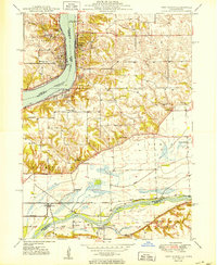
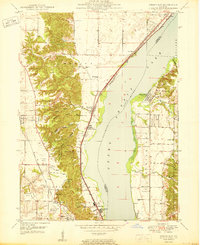 1950 Spring Bay1950 Print · USGSPeoria Lake and the Illinois River valley are seen here just after the war, showing the industrial and recreational growth of the riverfront. Researchers can locate the Mt Hawley Airport, the rail corridor of the Chicago Rock Island and Pacific, and the wooded hollows of Detweiller Park.2 unique versions available
 - 1950 Map of Milan
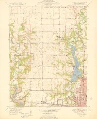
 1950 Milan1950 Print · USGSThe Tri-Cities area comes alive in the mid-century as industrial centers like Rock Island and Moline expand across the river islands. Researchers can locate dozens of local landmarks, from Chippiannock Cem to rural outposts like Tindall School No 1.2 unique versions available
 - 1950 Map of Alton
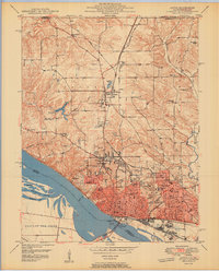 1950 Alton1950 Print · USGSAlton was a bustling river and rail hub at the mid-century, defined by its educational institutions and heavy river infrastructure. Trace the old campus of Western Military Academy, the riverfront at Lock and Dam No 26, and cemeteries like Confederate Cem.2 unique versions available
 - 1950 Map of Port Byron
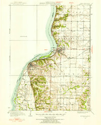
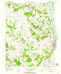
 1950 Port Byron1950 Print · USGSThe Illinois-Iowa border along the Mississippi River thrives as a rail and river hub at the middle of the twentieth century. Local historians can trace family roots through numerous rural landmarks like Shake-Rag Sch, St Johns Cem, and Rapids City.
 - 1950 Map of Danville SW
 1950 Danville SW1950 Print · USGSThe Vermilion County coalfields and rail hubs are captured here at mid-century. Researchers can trace family history through sites like Sts Peter and Paul Cem or the industrial landscape of the D Day Mine and Wabash Railroad.
 - 1950 Map of Danville NW
 1950 Danville NW1950 Print · USGSThe northwestern outskirts of Danville and the Vermilion River valley are captured here in the mid-century, as industrial mining and new recreational parks met. Genealogists and historians can trace the New York Central rail line past Eureka Sch, Hillery, and the grounds of Kickapoo State Park.
 - 1950 Map of Peoria West
 1950 Peoria West1950 Print · USGSMid-century Peoria is a bustling rail and river hub at the height of its industrial era. Genealogists and historians can trace the foundations of local communities through landmarks like the Peoria State Hospital, Golden Acres, and the Peoria Municipal Airport.
 - 1950 Map of Peoria East
 1950 Peoria East1950 Print · USGSPeoria and the Illinois River valley are shown here just after the war, at a peak of industrial and urban density. Genealogists and local historians can trace hundreds of family and community landmarks, from Springdale Cemetery to the neighborhoods of Creve Coeur and Peoria Heights.
 - 1950 Map of Springfield West
 1950 Springfield West1950 Print · USGSPost-war Springfield exhibits a complex network of railroads and civic institutions at the midpoint of the century. Trace family roots at Oak Ridge Cem or locate historic landmarks like the Lincoln Tomb and State Capitol.
 - 1950 Map of Springfield East
 1950 Springfield East1950 Print · USGSEast of the Illinois capital in the mid-twentieth century, a complex rail and river network shaped the landscape. Genealogists can trace family names through rural landmarks like St James Sch, Taylor Cem, and the U S Naval Training Sta.
 - 1950 Map of Edwardsville
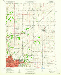
 1950 Edwardsville1950 Print · USGSEdwardsville and Glen Carbon are shown as thriving railroad and coal hubs at mid-century. Researchers can trace family roots through the numerous named schools and cemeteries like Pin Oak Sch, St James Cem, and the Black Diamond Coal Mine.2 unique versions available
 - 1950 Map of Tuscola, 1952 Print
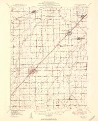
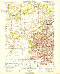
 1950 Tuscola1952 Print · USGSMid-century Douglas and Champaign Counties are mapped here at a time when the rural school system was fading into history. Genealogists can trace family roots through numerous markers like Stewart Sch, Macedonia Ch, and Bailey Memorial Cem.4 unique versions available
 - 1950 Map of Keokuk, 1954 Print
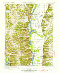
 1950 Keokuk1954 Print · USGSThe Mississippi River borderlands of Iowa and Illinois come alive in the mid-century as the Keokuk Dam reshapes the valley. Genealogists can trace a remarkable concentration of local landmarks, from Moss Cem to numerous rural schoolhouses like Rocky Run Sch and Eureka Sch.
 - 1950 Map of Pearl, 1956 Print
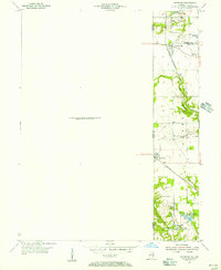
 1950 Pearl1956 Print · USGSThe Illinois River valley in the mid-1950s reveals a landscape of river-bottom farms and bluff-side settlements. Local researchers can trace family roots through numerous rural landmarks like Farmers Ridge Ch, Miller Cem, and Robley Sch.
 - 1950 Map of Sandford, 1956 Print
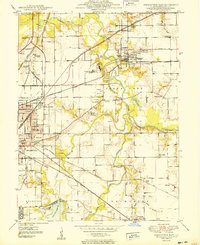
 1950 Sandford1956 Print · USGSStraddling the Illinois and Indiana border at the middle of the century, this area reveals a landscape shaped by coal mining and heavy rail. Genealogists can trace family roots in Sandford or Libertyville, or locate Pisgah Ch and the Green Valley Mine.
 - 1950 Map of Effingham, 1958 Print
 1950 Effingham1958 Print · USGSEffingham and the surrounding townships are shown at a mid-century peak of rail activity and rural development. Genealogists can trace family roots through numerous sites like Wolf Creek Cemetery, St Marys Church, and the settlement at Shumway.4 unique versions available
 - 1950 Map of La Grange, 1959 Print
 1950 La Grange1959 Print · USGSLewis County river towns and rural townships thrive along the Mississippi in the early fifties. Genealogists can trace family roots through numerous country schools like Pink Prairie Sch and the Marks Memorial Cem near La Grange.2 unique versions available
 - 1950 Map of Danville SE, 1960 Print
 1950 Danville SE1960 Print · USGSThe Illinois-Indiana borderlands at mid-century reveal a landscape defined by the winding Vermilion River and the expansion of southern Danville. Genealogists and local researchers can trace a dense network of family landmarks and rural institutions, from Sandhill Memorial Park to the Willow Springs Sch and Morey Chapel.
 - 1950 Map of Danville NE, 1962 Print
 1950 Danville NE1962 Print · USGSDanville and the surrounding Illinois-Indiana borderlands are captured here at a mid-century peak of rail and industry. Researchers can trace family roots through numerous rural institutions like Grange Hall Sch, Spring Hill Cemetery, and the Hopewell Ch.
 - 1950 Map of Dixon, 1964 Print
 1950 Dixon1964 Print · USGSThe Rock River valley in the mid-twentieth century shows a landscape of busy river towns and dense rural school districts. Genealogists can locate family-named landmarks like Tealls Corners School, Emmert School, and the White Temple church.2 unique versions available
 - 1950 Map of Canton, 1967 Print
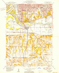
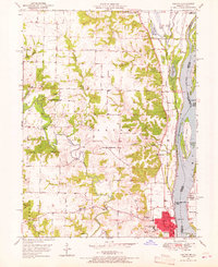 1950 Canton1967 Print · USGSMissouri river life at mid-century centered on the busy transit hub of Canton and its surrounding rural school districts. Genealogists and historians can trace local landmarks like Culver-Stockton College, the Canton Ferry, and numerous country schools from Hardin Sch to Melrose Sch.3 unique versions available
Showing maps 1-25 of 309
Top cities of Illinois
- Chicago historical maps
- Aurora historical maps
- Joliet historical maps
- Naperville historical maps
- Rockford historical maps
- Springfield historical maps
See more
Top counties of Illinois
- Cook County historical maps
- Lake County historical maps
- McHenry County historical maps
- Winnebago County historical maps
- Madison County historical maps
- Saint Clair County historical maps
See more
Frequently asked questions
- What are the different types of historical maps available for Illinois?
- What is the oldest map of Illinois?
- Where can I purchase historical maps of Illinois for my home or office?
- Where can I download high-res historical maps of Illinois?
- Are there historical topographic maps available for Illinois?
- Is there historical aerial imagery available for Illinois?
- Where are historical maps of Illinois sourced from?