1940s Maps of Illinois
Explore 220 historic maps of Illinois from the 1940s. These maps offer a rare glimpse into what life looked like during the 1940s — showing old roads, neighborhoods, homes, and landmarks that have changed or disappeared over time.
Whether you're researching your family's past, planning a metal detecting trip, or studying how Illinois's landscape evolved across the 1940s, these high-resolution maps are a powerful tool for exploring the history of this region.
- Focus on a specific era: All maps on this page are from the 1940s, giving you a focused view of this time period.
- See what’s changed: Compare century-old streets, trails, and buildings to today's modern landscape using overlays and satellite layers.
- Research with precision: Use these maps for genealogy, historical research, land use analysis, or educational projects.
- View, download, or print: Maps are fully viewable online in high resolution, and can be downloaded or printed for your own records.
Start exploring Illinois's history through authentic maps from the 1940s. This is your window into the past.
Illinois maps
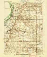
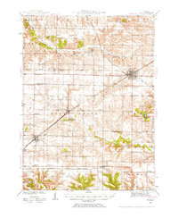
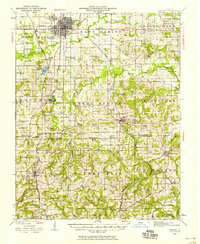
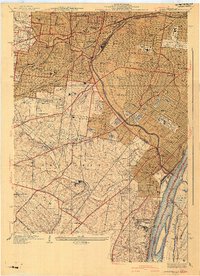
(220)- 1940 Map of Morrison
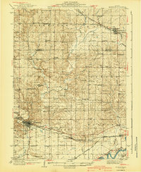 1940 Morrison1940 Print · USGSWhiteside and Carroll counties thrive as a robust agricultural landscape during the late 1930s, defined by the twin engines of the Rock River and major rail lines. Genealogists can locate dozens of country schools like Ideal Sch and old cemeteries including Clyde Cem and Bethel Cem.2 unique versions available
 - 1940 Map of Sullivan
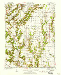
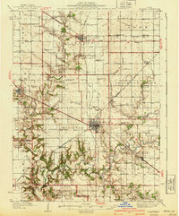 1940 Sullivan1940 Print · USGSCentral Illinois is seen here just before the Second World War, showing a landscape defined by small townships and an extensive rail network. Genealogists and local researchers can locate dozens of country schools like Hewitt Sch and Titus Sch, or trace family sites such as Wright Cem and the Masonic Home.2 unique versions available
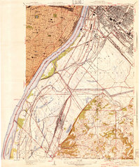
 - 1940 Map of Granite City
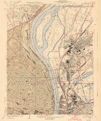 1940 Granite City1940 Print · USGSThe industrial heart of the bi-state region comes alive in this 1940s survey of the riverfront between Illinois and Missouri. Researchers can trace the massive rail yards and river docks supporting Granite City, alongside historic landmarks like Union Station, St Louis University, and the Bellefontaine Cemetery.4 unique versions available
 - 1940 Map of Cahokia
 1940 Cahokia1940 Print · USGSThe industrial riverfront south of St Louis thrived in the early twentieth century as a massive rail and shipping hub. Trace the development of Cahokia and Dupo or locate landmarks like the U S Marine Hospital and the Lark Cem.3 unique versions available
 - 1940 Map of Oquawka
 1940 Oquawka1940 Print · USGSHenderson County's river-and-rail economy is captured here during the 1930s as the Mississippi River environment meets an expanding network of rural towns. Genealogists and historians can trace dozens of country schoolhouses and cemeteries, from the Little Brick Sch to South Henderson Cem.2 unique versions available
 - 1940 Map of Burlington
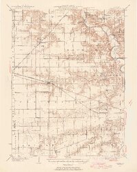
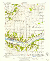
 1940 Burlington1940 Print · USGSThe Mississippi River floodplain comes alive in the mid-1930s, showing the intricate network of sloughs and rail lines between Illinois and Iowa. Genealogists and historians can locate rural landmarks like Merry Dell Sch, trace the Chicago Burlington and Quincy tracks, or explore the riverfront at Gulfport.3 unique versions available
 - 1940 Map of Mount Vernon
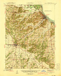
 1940 Mount Vernon1940 Print · USGSMount Vernon and the surrounding Jefferson County countryside are captured here during the late Depression years. Researchers can trace rural family life through dozens of named country schools and churches like George College Sch, Old Shiloh Ch, and Atkinson Cem.2 unique versions available
 - 1940 Map of East Dubuque
 1940 East Dubuque1940 Print · USGSThe Mississippi River borderlands of Jo Daviess County appear here in the mid-1930s, showing the vital rail and river connections at East Dubuque. Genealogists and local historians can trace rural school districts like Sand Ridge Sch or the riverside community of Menominee Sta.3 unique versions available
 - 1940 Map of Arcola
 1940 Arcola1940 Print · USGSThe Douglas and Coles County borderlands come alive in this pre-war portrait of central Illinois agricultural life. Researchers can trace dozens of rural school sites such as Pulltight Sch and Little Red Sch, alongside old rail corridors like the Illinois Central.
 - 1940 Map of Bowling Green
 1940 Bowling Green1940 Print · USGSPike County at the end of the Depression reveals a landscape tied to the Mississippi River and a thriving rail network. Genealogists can trace family roots through dozens of rural landmarks like St Clement, Stark Nursery, and the Noix Creek Cem.2 unique versions available
 - 1940 Map of Renault, 1955 Print
 1940 Renault1955 Print · USGSThe Illinois-Missouri borderlands come to life in the 1940s, highlighting the river-driven economy and rural community structure of the Mississippi valley. Genealogists can trace family footprints through dozens of local landmarks, from the Ruma Convent to historic schoolhouses like Yankeetown School and Foster School.2 unique versions available
 - 1940 Map of Tallula, 1956 Print
 1940 Tallula1956 Print · USGSCentral Illinois during the late thirties and early forties reveals a landscape of river-bluff history and active rail towns. Genealogists can trace family connections in Tallula, Salisbury, and Berlin, or locate the historic New Salem State Park.2 unique versions available
 - 1940 Map of Elgin, 1957 Print
 1940 Elgin1957 Print · USGSKane and McHenry Counties at the start of the 1940s reveal a landscape of bustling river towns and quiet prairie schools. Researchers can trace family roots through numerous local landmarks like Munshawville School, the State Hospital, and the rail junction at Huntley.
 - 1940 Map of Galva, 1957 Print
 1940 Galva1957 Print · USGSHenry and Knox counties are captured here as a bustling railroad landscape in the early 1940s. Genealogists can trace the rural school and church networks of the era, from the uniquely named Swamp College Sch to the settlement at Bishop Hill.2 unique versions available
 - 1940 Map of Greenup, 1958 Print
 1940 Greenup1958 Print · USGSCumberland and Jasper Counties are shown in detail as they appeared just before the war, dominated by the winding valley of the Embarrass River. Genealogists can trace dozens of country schools and churches, including Scotch Chapel Sch, Hazel Dell, and Washington Cem.2 unique versions available
 - 1940 Map of Okawville, 1958 Print
 1940 Okawville1958 Print · USGSSouthwestern Illinois at the start of the 1940s remains a landscape of tight-knit farming hamlets and river-bottom wetlands. Researchers can trace the heritage of German settlements and rail stops from St Libory and Darmstadt to the mineral springs area of Okawville.
 - 1940 Map of Marseilles, 1958 Print
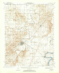
 1940 Marseilles1958 Print · USGSLaSalle and Grundy counties appear here during the transition from the canal era to the railway age. Genealogists and local historians can trace family-named school sites like Ness School and Barry School or locate the village of Stavanger.
 - 1940 Map of Paducah, 1958 Print
 1940 Paducah1958 Print · USGSAcross the river from Illinois at the start of the 1940s, this area captures Paducah and Metropolis at a peak of rail and river activity. Researchers can trace the Illinois Central RR lines, locate family markers at Veyer Cemetery, and find rural landmarks like Klondike Sch and Palestine Ch.
 - 1940 Map of Marion, 1958 Print
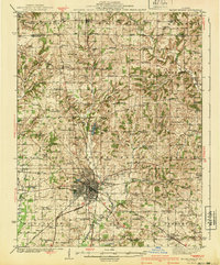
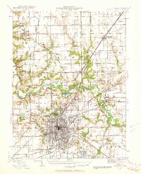
 1940 Marion1958 Print · USGSSouthern Illinois during the early 1940s reveals a landscape defined by its rail junctions and scattered rural schools. Genealogists can trace family roots through sites like Bainbridge Cem, Pulleys Mill, and the many schools like Skaggs School.
 - 1940 Map of Springfield, 1959 Print
 1940 Springfield1959 Print · USGSSpringfield and its surrounding townships appear here as a bustling pre-war rail and aviation center. Researchers can trace family roots through numerous rural schools like Locate Lane Sch or historical sites like Lindbergh Air Mail Field and Camp Butler Cem.2 unique versions available
 - 1940 Map of Carmi, 1965 Print
 1940 Carmi1965 Print · USGSThe river-and-rail hub of Carmi and the surrounding White County prairies are documented here just before the mid-century. Researchers can trace rural family roots through dozens of named sites like Miller Cem, Stokes Chapel, and Williams Sch.
 - 1941 Map of Miles
 1941 Miles1941 Print · USGSThe Mississippi River borderlands come alive in this pre-war survey, documenting the small settlements and rail lines that defined the Jo Daviess and Carroll County line. Researchers can trace the river's complex island system or find local landmarks like Whitton, Lost Mound, and the Lost Mound Sch.2 unique versions available
 - 1941 Map of Jefferson Barracks
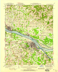
 1941 Jefferson Barracks1941 Print · USGSThe suburbs south of St. Louis were maturing into a dense network of rail-side towns and institutions just before the mid-century. Genealogists and historians can trace family roots through numerous sites like Grants Farm, National Cemetery, and Webster College.3 unique versions available
 - 1941 Map of Keithsburg
 1941 Keithsburg1941 Print · USGSThe Mississippi River front in Mercer County thrived during the early 1940s as a hub of rail and river commerce. Genealogists can trace family footprints through dozens of rural landmarks, from Peniel Ch to schoolhouses like Prouty Sch and Lee Sch.2 unique versions available
 - 1941 Map of Carbondale, 1955 Print
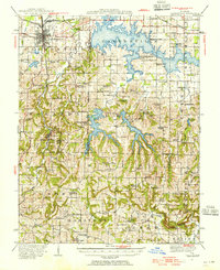 1941 Carbondale1955 Print · USGSSouthern Illinois was undergoing a transformation in the early 1940s as new reservoirs reshaped the topography near Carbondale. Researchers can trace rural life through dozens of named sites like Clemmenstown School and South County Line Church.2 unique versions available
Showing maps 1-25 of 220
Top cities of Illinois
- Chicago historical maps
- Aurora historical maps
- Joliet historical maps
- Naperville historical maps
- Rockford historical maps
- Springfield historical maps
See more
Top counties of Illinois
- Cook County historical maps
- Lake County historical maps
- McHenry County historical maps
- Winnebago County historical maps
- Madison County historical maps
- Saint Clair County historical maps
See more
Frequently asked questions
- What are the different types of historical maps available for Illinois?
- What is the oldest map of Illinois?
- Where can I purchase historical maps of Illinois for my home or office?
- Where can I download high-res historical maps of Illinois?
- Are there historical topographic maps available for Illinois?
- Is there historical aerial imagery available for Illinois?
- Where are historical maps of Illinois sourced from?