
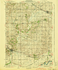
1940 Map of Morrison
USGS Topo · Published 1940About this map
The Chicago and Northwestern railroad corridor anchors the southern landscape of this Whiteside County survey, connecting the busy hub of Morrison to smaller whistle-stops like Round Grove and Galt. The terrain is defined by a dense network of country schools and rural churches, reflecting the high agricultural population density of the late 1930s. Notable community landmarks include the Dutchtown Ch near Milledgeville and the Genesee Grove Ch tucked alongside the winding Little Rock Creek.
Find a feature on this map
77 named features on this map. Tap any name to fly to it.
Don’t see what you’re looking for? This feature index may not catch every label — zoom into the map to look around manually.
Map Details
Editions of this 1940 Morrison Map
2 editions found
Other maps of this area

1891 · Clinton
USGS Topo · 1:62,500

1892 · Savanna
USGS Topo · 1:62,500

1894 · Clinton
USGS Topo · 1:62,500

1899 · Clinton
USGS Topo · 1:125,000

1930 · Woodsung
USGS Topo · 1:48,000

1932 · Prophetstown
USGS Topo · 1:48,000

1934 · Morrison
USGS Topo · 1:48,000

1936 · Prophetstown
USGS Topo · 1:62,500

1942 · Mt Carroll
USGS Topo · 1:62,500

1942 · Forreston
USGS Topo · 1:62,500