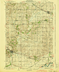
1940 Map of Morrison
USGS Topo · Published 1940About this map
The town of Morrison serves as a significant hub on this mid-century survey, situated at the junction of the Chicago and Northwestern railroad and a network of arterial roads. The landscape transition from the rolling drainage basins of Rock Creek and Otter Creek in the north to the fertile plains near the Rock River in the south is densely populated with small-scale agrarian infrastructure. A notable density of country schools, such as Hartman Sch, Hazel Green Sch, and Hickory Grove Sch, suggests a series of established rural neighborhoods that formed the backbone of Whiteside County before school consolidation changed the local landscape. In the northeastern corner, Milledgeville anchors a secondary cluster of development along the Chicago Burlington and Quincy line. Throughout the townships of Clyde, Genesee, and Mt Pleasant, numerous small burial grounds like Calvord Cem and Heaton Cem offer specific locations for genealogical research into early Illinois pioneer families.
Find a feature on this map
83 named features on this map. Tap any name to fly to it.
Don’t see what you’re looking for? This feature index may not catch every label — zoom into the map to look around manually.
Map Details
Editions of this 1940 Morrison Map
2 editions found
Other maps of this area

1891 · Clinton
USGS Topo · 1:62,500

1892 · Savanna
USGS Topo · 1:62,500

1894 · Clinton
USGS Topo · 1:62,500

1899 · Clinton
USGS Topo · 1:125,000

1930 · Woodsung
USGS Topo · 1:48,000

1932 · Prophetstown
USGS Topo · 1:48,000

1934 · Morrison
USGS Topo · 1:48,000

1936 · Prophetstown
USGS Topo · 1:62,500

1940 · Morrison
USGS Topo · 1:62,500

1942 · Mt Carroll
USGS Topo · 1:62,500