
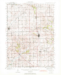
1942 Map of Forreston
USGS Topo · Published 1965About this map
Forreston sits at a critical junction of three major railroads, serving as a hub for the agricultural landscape of Ogle and Stephenson Counties during the mid-twentieth century. The Chicago Milwaukee St Paul and Pacific, Chicago Great Western, and Illinois Central lines crisscross the terrain, connecting small shipping points like Harper and Haldane to larger markets. This era of rural education is exceptionally well-documented here, with dozens of one-room schoolhouses such as Van Brocklin Sch and Sunnyside Sch serving family farms before the widespread consolidation of districts. The land transitions from the level fields of Prairie Hill in the north to the more varied topography of Coffman Ridge and Elkhorn Grove in the south, where Elkhorn Creek and its tributaries define the drainage patterns of the prairie.
Find a feature on this map
63 named features on this map. Tap any name to fly to it.
Don’t see what you’re looking for? This feature index may not catch every label — zoom into the map to look around manually.
Map Details
Editions of this 1942 Forreston Map
2 editions found
Other maps of this area

1918 · Dixon
USGS Topo · 1:62,500

1922 · Oregon
USGS Topo · 1:62,500

1924 · Oregon
USGS Topo · 1:62,500

1930 · Woodsung
USGS Topo · 1:48,000

1932 · Pecatonica
USGS Topo · 1:62,500

1934 · Morrison
USGS Topo · 1:48,000

1936 · Pecatonica
USGS Topo · 1:62,500

1937 · Lena
USGS Topo · 1:48,000

1939 · Freeport
USGS Topo · 1:48,000

1940 · Morrison
USGS Topo · 1:62,500