
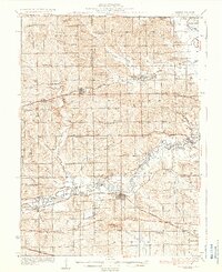
1936 Map of Pecatonica
USGS Topo · Published 1936About this map
The Pecatonica River winds through the heart of this mid-1930s landscape, defining the character of northern Illinois near the Wisconsin State Line. The map reveals a dense network of local education and community centers, with nearly every section of land supported by a named schoolhouse like College Sch, Irish Grove Sch, or Pleasant Valley Sch. The railroad-driven economy of the era is evident in the parallel lines of the Chicago Milwaukee St Paul and Pacific and the Chicago and Northwestern lines, which connect the established hubs of Pecatonica and Durand to the surrounding agricultural prairie. These rails, along with the Illinois Central to the south, highlight the region's importance as a transit corridor between rural townships and larger markets. Local family landmarks and small rural junctions like Ridott Corners and Woodruff Corners provide specific points of interest for those tracing early 20th-century settlement patterns.
Find a feature on this map
85 named features on this map. Tap any name to fly to it.
Don’t see what you’re looking for? This feature index may not catch every label — zoom into the map to look around manually.
Map Details
Editions of this 1936 Pecatonica Map
2 editions found
Other maps of this area

1891 · Janesville
USGS Topo · 1:62,500

1893 · Janesville
USGS Topo · 1:62,500

1893 · Brodhead
USGS Topo · 1:62,500

1917 · Kings
USGS Topo · 1:62,500

1918 · Rockford
USGS Topo · 1:62,500

1918 · Kings
USGS Topo · 1:62,500

1920 · Monroe
USGS Topo · 1:62,500

1922 · Monroe
USGS Topo · 1:62,500

1922 · Oregon
USGS Topo · 1:62,500

1924 · Oregon
USGS Topo · 1:62,500