
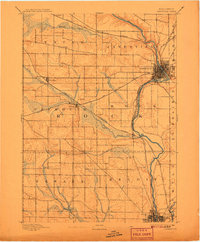
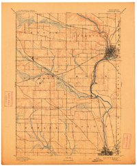
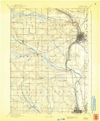
1893 Map of Janesville
USGS Topo · Published 1893About this map
The Rock River valley serves as the central artery for this late 19th-century portrait of Rock County, anchoring the growing industrial hubs of Janesville and Beloit. Surveyed by Van. H. Manning Jr. in 1891, the landscape is defined by the intersection of major transit corridors, specifically the Chicago and Northwestern Railroad and the Chicago Milwaukee and St. Paul Railroad. These rail lines dictate the placement of smaller agricultural depots and settlements such as Hanover, Afton, and Footville. Away from the river, the terrain transitions into the organized township grids of Center, Plymouth, and Newark, where smaller landmarks like Stevens and Fellows represent the rural community structure of the era. The map also captures the natural hydrology of the region, including the winding course of Marsh Creek and Bass Creek as they feed into the primary river system.
Find a feature on this map
25 named features on this map. Tap any name to fly to it.
Don’t see what you’re looking for? This feature index may not catch every label — zoom into the map to look around manually.
Map Details
Editions of this 1893 Janesville Map
4 editions found
Other maps of this area

1889 · Evansville
USGS Topo · 1:62,500

1890 · Stoughton
USGS Topo · 1:62,500

1891 · Koshkonong
USGS Topo · 1:62,500

1891 · Janesville
USGS Topo · 1:62,500

1893 · Brodhead
USGS Topo · 1:62,500

1893 · Shopiere
USGS Topo · 1:62,500

1894 · Evansville
USGS Topo · 1:62,500

1894 · Koshkonong
USGS Topo · 1:62,500

1906 · Evansville
USGS Topo · 1:62,500

1906 · Koshkonong
USGS Topo · 1:62,500