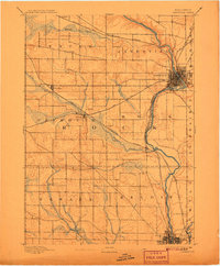
1893 Map of Janesville
USGS Topo · Published 1898About this map
The Rock River corridor serves as the industrial and logistical spine of this late 19th-century landscape, connecting the growing hubs of Janesville and Beloit. Surveyed by Van H. Manning Jr. in 1891, the map reveals a region defined by its reliance on water power and heavy rail transport. Two major lines, the Chicago and Northwestern Railroad and the Chicago Milwaukee and St. Paul Railroad, crisscross the townships of Plymouth and Rock, intersecting at strategic points like Hanover.
Find a feature on this map
21 named features on this map. Tap any name to fly to it.
Don’t see what you’re looking for? This feature index may not catch every label — zoom into the map to look around manually.
Map Details
Editions of this 1893 Janesville Map
4 editions found
Other maps of this area

1889 · Evansville
USGS Topo · 1:62,500

1890 · Stoughton
USGS Topo · 1:62,500

1891 · Koshkonong
USGS Topo · 1:62,500

1891 · Janesville
USGS Topo · 1:62,500

1893 · Janesville
USGS Topo · 1:62,500

1893 · Brodhead
USGS Topo · 1:62,500

1893 · Shopiere
USGS Topo · 1:62,500

1894 · Evansville
USGS Topo · 1:62,500

1894 · Koshkonong
USGS Topo · 1:62,500

1906 · Evansville
USGS Topo · 1:62,500