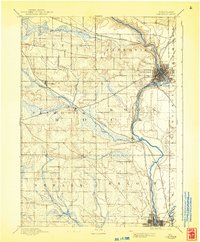
1893 Map of Janesville
USGS Topo · Published 1943About this map
The Rock River corridor serves as the industrial and transit spine of Rock County in the late nineteenth century, anchoring the primary settlements of Janesville and Beloit. While these urban hubs show early grid expansion, the surrounding landscape is defined by a dense network of iron rail and waterpower. Two major carriers, the Chicago and Northwestern Railroad and the Chicago Milwaukee and St. Paul Railroad, intersect at multiple points, fostering smaller rail stops like Hanover and Afton.
Find a feature on this map
25 named features on this map. Tap any name to fly to it.
Don’t see what you’re looking for? This feature index may not catch every label — zoom into the map to look around manually.
Map Details
Editions of this 1893 Janesville Map
4 editions found
Other maps of this area

1889 · Evansville
USGS Topo · 1:62,500

1890 · Stoughton
USGS Topo · 1:62,500

1891 · Koshkonong
USGS Topo · 1:62,500

1891 · Janesville
USGS Topo · 1:62,500

1893 · Janesville
USGS Topo · 1:62,500

1893 · Brodhead
USGS Topo · 1:62,500

1893 · Shopiere
USGS Topo · 1:62,500

1894 · Evansville
USGS Topo · 1:62,500

1894 · Koshkonong
USGS Topo · 1:62,500

1906 · Evansville
USGS Topo · 1:62,500