
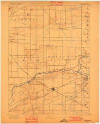
1893 Map of Shopiere
USGS Topo · Published 1893About this map
Clinton Junction serves as the primary rail hub on this 1891 survey, where the Chicago and Northwestern Railroad intersects with the Chicago Milwaukee and St. Paul Railroad. This crossing anchored the local economy during the late nineteenth century, providing essential transport for the surrounding agricultural townships of Rock, Turtle, and Clinton. The landscape is defined by the winding course of Turtle Creek, which flows southwest toward the Rock River valley. Along its banks, the settlement of Shopiere and the nearby Shopiere Depot illustrate the separation between established village centers and the newer trackside developments of the era. Smaller communities like Emerald Grove, Fairfield, and Allen Grove dot the grid of country roads, marking the steady expansion of Rock County's rural settlement pattern before the turn of the century.
Find a feature on this map
24 named features on this map. Tap any name to fly to it.
Don’t see what you’re looking for? This feature index may not catch every label — zoom into the map to look around manually.
Map Details
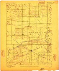
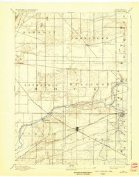
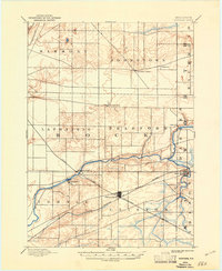
Editions of this 1893 Shopiere Map
5 editions found
Other maps of this area

1890 · Stoughton
USGS Topo · 1:62,500

1891 · Koshkonong
USGS Topo · 1:62,500

1891 · Janesville
USGS Topo · 1:62,500

1892 · Whitewater
USGS Topo · 1:62,500

1893 · Delavan
USGS Topo · 1:62,500

1893 · Whitewater
USGS Topo · 1:62,500

1893 · Janesville
USGS Topo · 1:62,500

1894 · Koshkonong
USGS Topo · 1:62,500

1903 · Whitewater
USGS Topo · 1:62,500

1906 · Koshkonong
USGS Topo · 1:62,500