
1892 Map of Whitewater
USGS Topo · Published 1892About this map
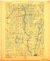
Glacial drumlins and extensive wetlands define the terrain of southeastern Wisconsin in this late nineteenth-century survey. The Prairie Du Chien Division Chicago Milwaukee And St. Paul Railroad serves as a primary corridor, connecting the established grid of Whitewater to the village of Palmyra. The landscape is a mosaic of water and marsh, with the Bark River and Scuppernong River winding through lowlands between smaller settlements like Hebron and Rome.
Find a feature on this map
28 named features on this map. Tap any name to fly to it.
Don’t see what you’re looking for? This feature index may not catch every label — zoom into the map to look around manually.
Map Details
Editions of this 1892 Whitewater Map
This is the sole edition of this map. No revisions or reprints were ever made.
Other maps of this area

1891 · Waterloo
USGS Topo · 1:62,500

1891 · Koshkonong
USGS Topo · 1:62,500

1892 · Watertown
USGS Topo · 1:62,500

1892 · Oconomowoc
USGS Topo · 1:62,500

1892 · Eagle
USGS Topo · 1:62,500

1893 · Delavan
USGS Topo · 1:62,500

1893 · Whitewater
USGS Topo · 1:62,500

1893 · Shopiere
USGS Topo · 1:62,500

1893 · Geneva
USGS Topo · 1:62,500
1894 · Waterloo
USGS Topo · 1:62,500