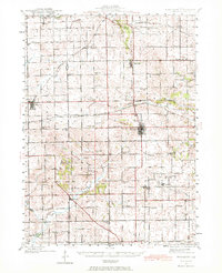
1942 Map of Forreston
USGS Topo · Published 1972About this map
Forreston serves as a central rail hub on this mid-century survey, where the Chicago Milwaukee St Paul and Pacific and the Chicago Great Western railroads intersect. The surrounding countryside in Ogle and Stephenson Counties is defined by a dense network of local institutions, including numerous one-room schoolhouses like Evergreen Sch and Chambers Grove Sch that anchored these farming communities before the era of school consolidation.
Find a feature on this map
86 named features on this map. Tap any name to fly to it.
Don’t see what you’re looking for? This feature index may not catch every label — zoom into the map to look around manually.
Map Details
Editions of this 1942 Forreston Map
2 editions found

Other maps of this area

1918 · Dixon
USGS Topo · 1:62,500

1922 · Oregon
USGS Topo · 1:62,500

1924 · Oregon
USGS Topo · 1:62,500

1930 · Woodsung
USGS Topo · 1:48,000

1932 · Pecatonica
USGS Topo · 1:62,500

1934 · Morrison
USGS Topo · 1:48,000

1936 · Pecatonica
USGS Topo · 1:62,500

1937 · Lena
USGS Topo · 1:48,000

1939 · Freeport
USGS Topo · 1:48,000

1940 · Morrison
USGS Topo · 1:62,500