1930s Maps of Illinois
Explore 143 historic maps of Illinois from the 1930s. These maps offer a rare glimpse into what life looked like during the 1930s — showing old roads, neighborhoods, homes, and landmarks that have changed or disappeared over time.
Whether you're researching your family's past, planning a metal detecting trip, or studying how Illinois's landscape evolved across the 1930s, these high-resolution maps are a powerful tool for exploring the history of this region.
- Focus on a specific era: All maps on this page are from the 1930s, giving you a focused view of this time period.
- See what’s changed: Compare century-old streets, trails, and buildings to today's modern landscape using overlays and satellite layers.
- Research with precision: Use these maps for genealogy, historical research, land use analysis, or educational projects.
- View, download, or print: Maps are fully viewable online in high resolution, and can be downloaded or printed for your own records.
Start exploring Illinois's history through authentic maps from the 1930s. This is your window into the past.
Illinois maps
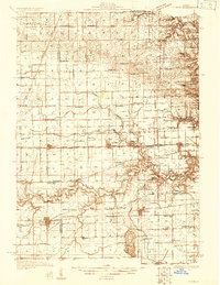
(143)- 1930 Map of Danvers
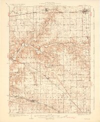 1930 Danvers1930 Print · USGSCentral Illinois farming communities are frozen in time just before the Depression, showing a landscape defined by the Mackinaw River and thriving rail lines. Genealogists can locate family-named schoolhouses like Strubhar Sch and early religious centers like East White Oak Ch.2 unique versions available
 - 1930 Map of Pearl
 1930 Pearl1930 Print · USGSThe Illinois River valley in the late 1920s shows a landscape of river-bottom farms and rugged bluff-top settlements. Genealogists can locate family landmarks like Miller Cem, Farmers Ridge Ch, and schools such as Summit Grove Sch or Village Green Sch.3 unique versions available
 - 1930 Map of Chandlerville
 1930 Chandlerville1930 Print · USGSThe confluence of the Illinois and Sangamon rivers defines this Depression-era landscape of floodplains and island farms. Genealogists can trace family footprints across Grand Island or locate rural landmarks like Mt Olive Ch and the Chicago and Illinois Midland RR.2 unique versions available
 - 1930 Map of Dyer
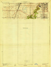
 1930 Dyer1930 Print · USGSThe Illinois-Indiana borderlands appear in the late twenties during a period of industrial and automotive growth. Genealogists and local historians can trace early schoolhouse locations like Cats Corner School and the path of the famous Lincoln Highway near Dyer.
 - 1930 Map of Woodsung
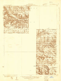
 1930 Woodsung1930 Print · USGSNorthern Illinois at the dawn of the 1930s shows a landscape of tight-knit farming townships linked by the Lincoln Highway. Genealogists and local historians can trace schoolhouse locations like Stone Sch and Gap Grove Sch, or locate family sites near the Prairieville Cem.
 - 1930 Map of Frankfort
 1930 Frankfort1930 Print · USGSThe village of Frankfort sits at the junction of the Elgin, Joliet, and Eastern and the historic Sauk Trail in the late twenties. Trace local history at the Washington Royal School, Rahm School, and Pleasant Hill Cem.2 unique versions available
 - 1930 Map of Steger
 1930 Steger1930 Print · USGSThe southern outskirts of Chicago thrived as a rail and industrial nexus in the late twenties. Genealogists and historians can trace the early footprints of South Chicago Heights and Matteson, locating landmarks like St Annes Church and the Calvary Cemetery.2 unique versions available
 - 1930 Map of Springfield
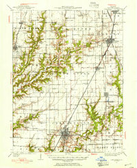
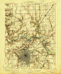 1930 Springfield1930 Print · USGSSpringfield and its surrounding farming townships are seen here in the late twenties, captured as a vital crossroads of rail and road. Genealogists can locate family-named landmarks like Derry Farm and over two dozen country schools, including Crankneck Sch and American Hill Sch.3 unique versions available
 - 1930 Map of Glasford
 1930 Glasford1930 Print · USGSCentral Illinois river towns and upland prairie farms thrive in the late twenties between the Illinois River and Hanna City. Researchers can trace old coal operations at Baxter Mine or locate family roots at Penn Ridge Ch and Union Cemetery.3 unique versions available
 - 1930 Map of Nebo
 1930 Nebo1930 Print · USGSThe Mississippi River bottomlands and Pike County bluffs are shown here in the late twenties, featuring a landscape of sloughs and rail-dependent towns. Trace family roots at Wildcat Cem or locate rural landmarks like Riprap Landing and Old Baptist Sch.
 - 1930 Map of Normal
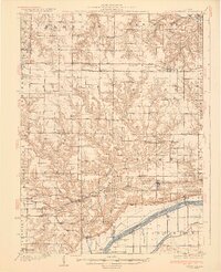
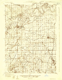
 1930 Normal1930 Print · USGSMcLean County is captured here in the late twenties, showing a rural landscape defined by rail lines and a school in nearly every section. Genealogists can locate specific landmarks like the Little Red Sch, the Town Hall in Money Creek, and the old rail corridors of the Chicago and Alton.2 unique versions available
 - 1930 Map of Hardin
 1930 Hardin1930 Print · USGSCalhoun County's narrow peninsula is captured here between the two great rivers during the late Prohibition era. Genealogists and local researchers can locate numerous rural landmarks like Indian Creek Ch, Oases Ch, and a high concentration of schoolhouses including South Lincoln Sch.2 unique versions available
 - 1930 Map of Jerseyville, 1965 Print
 1930 Jerseyville1965 Print · USGSJersey and Greene Counties are captured here between the world wars, showing a landscape defined by steam rail and one-room schoolhouses. Genealogists can trace the exact locations of Old Kane, the County Farm, and numerous local landmarks like St Marys Sch.2 unique versions available
 - 1931 Map of Hoyleton
 1931 Hoyleton1931 Print · USGSWashington County at the start of the 1930s shows a landscape of busy crossroads and rail junctions. Genealogists can trace family roots through numerous local schoolhouses like Nuptial Sch and Hogshead Sch, or locate ancestors at the Masonic Cem.
 - 1931 Map of Galva
 1931 Galva1931 Print · USGSThe Henry and Knox County borderlands are mapped here in the early 1930s, showing a thriving network of rural townships and rail corridors. Researchers can locate dozens of country schools and churches, from Swamp College Sch to the North Ontario Ch and the Galva Cem.
 - 1931 Map of Barry
 1931 Barry1931 Print · USGSPike County bottomlands along the Mississippi River are shown here in the late twenties and early thirties, just as drainage projects transformed the landscape. Genealogists and local historians can trace rural school locations like Guss Sch and Munger Sch, or find family burials at Money Cem and Blackjack Cem.
 - 1931 Map of Fithian
 1931 Fithian1931 Print · USGSVermilion County and its neighboring townships thrive in the early 1930s as a hub of rail travel and rural education. Genealogists can trace hundreds of family sites near Knights Branch Cem, Fowler Sch, and the busy rail yards of Homer.
 - 1931 Map of Meredosia
 1931 Meredosia1931 Print · USGSThe Illinois River valley in the late twenties is captured here at a peak of rail and river activity. Genealogists can trace family roots through numerous country schools like Sand Ridge Sch and the important La Grange Locks complex.2 unique versions available
 - 1931 Map of Brussels
 1931 Brussels1931 Print · USGSThe peninsula between the Illinois and Mississippi Rivers is captured here in the early 1930s, showcasing a network of river landings and ridge-top settlements. Genealogists can trace family roots through numerous local landmarks like Golden Eagle, Point Pleasant, and Nichols Sch.2 unique versions available
 - 1931 Map of Cairo, 1954 Print
 1931 Cairo1954 Print · USGSSouthern Illinois and western Kentucky meet at the great river confluence during the late 1920s and early 1930s. Genealogists can trace family footprints through numerous rural landmarks like Pleasant Hill Sch, the National Cem, and the riverfront at Mound City.2 unique versions available
 - 1931 Map of French Village, 1954 Print
 1931 French Village1954 Print · USGSSt. Clair County's industrial and residential corridors are frozen in time during the early thirties, showing the dense rail networks and coal mining operations of the era. Genealogists can locate family landmarks like Twiss Hill Sch, the Booker T Washington Cemetery, and Gundlach Mines.
 - 1931 Map of Carlinville, 1955 Print
 1931 Carlinville1955 Print · USGSMacoupin County in the early thirties is captured here as a bustling network of rail lines and rural school districts. Researchers can trace the paths of the Illinois Traction System and locate dozens of local landmarks like Coops Mound, Antioch Church, and Grimmett School.3 unique versions available
 - 1932 Map of Prophetstown
 1932 Prophetstown1932 Print · USGSProphetstown and the Rock River valley are depicted here in the early 1930s, showing a rural landscape crisscrossed by an extensive system of drainage ditches and canals. Researchers can locate dozens of small schools and local landmarks, including Hamilton Grave Sch, the Lyndon Cemetery, and Denrock Station.
 - 1932 Map of Harvard
 1932 Harvard1932 Print · USGSNorthern Illinois and the Wisconsin borderlands are captured here in the early 1930s, centered on the rail hub of Harvard. Genealogists can locate dozens of named rural schools like Hoppen School and Shields School, or trace the path of the Chicago and Northwestern Electric (Abandoned) line.3 unique versions available
 - 1932 Map of Hannibal
 1932 Hannibal1932 Print · USGSAlong the Mississippi River in the early 1930s, this survey captures the riverfront from Hannibal across to the Illinois bottomlands. Researchers can trace the river rail crossings of the WABASH and locate rural landmarks like Bird Slough Sch and the CHENALE ECARTE CLUB.4 unique versions available
Showing maps 1-25 of 143
Top cities of Illinois
- Chicago historical maps
- Aurora historical maps
- Joliet historical maps
- Naperville historical maps
- Rockford historical maps
- Springfield historical maps
See more
Top counties of Illinois
- Cook County historical maps
- Lake County historical maps
- McHenry County historical maps
- Winnebago County historical maps
- Madison County historical maps
- Saint Clair County historical maps
See more
Frequently asked questions
- What are the different types of historical maps available for Illinois?
- What is the oldest map of Illinois?
- Where can I purchase historical maps of Illinois for my home or office?
- Where can I download high-res historical maps of Illinois?
- Are there historical topographic maps available for Illinois?
- Is there historical aerial imagery available for Illinois?
- Where are historical maps of Illinois sourced from?