1888 Map of St. Louis
USGS Topo · Published 1888About this map
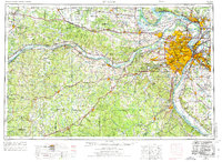
The Mississippi River serves as the central artery for this late-19th-century landscape, defined by a complex web of industrial transit and ancient earthworks. East of the dense urban grid of St. Louis, the Illinois floodplain, protected by the American Bottom Levee, reveals a high concentration of rail lines such as the Wabash St Louis and Pacific Railroad and the Ohio and Mississippi Railroad converging on East St Louis. These corridors supported a string of emerging settlements like Brooklyn, Venice, and French Village.
Find a feature on this map
65 named features on this map. Tap any name to fly to it.
Don’t see what you’re looking for? This feature index may not catch every label — zoom into the map to look around manually.
Map Details
Editions of this 1888 St. Louis Map
This is the sole edition of this map. No revisions or reprints were ever made.
Historical Maps of St. Louis Through Time
4 maps found