
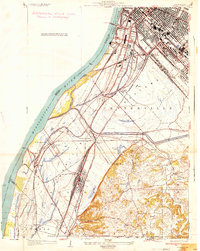
1931 Map of French Village
USGS Topo · Published 1954About this map
The Alton and Southern RR and numerous other rail lines intersect across this landscape, illustrating the industrial density of the area between East Louisville and Belleville in the early 1930s. The northern portion is characterized by the expansive Grand Marais State Park and Grand Marais Lake, while the eastern terrain rises into the bluffs near Signal Hill and Briar Hill. This survey highlights a mix of residential growth and industry, featuring the Gundlach Mines and several Clay Pits. Local genealogy is well-represented through numerous schools such as Twiss Hill Sch and Ogles Sta Sch, alongside several significant cemeteries including Mt Hope Cem and the Booker T Washington Cemetery. This era shows the region as a complex network of transit and community, where the St Louis and Belleville Electric RR connected emerging suburbs like Edgemont and French Village.
Find a feature on this map
72 named features on this map. Tap any name to fly to it.
Don’t see what you’re looking for? This feature index may not catch every label — zoom into the map to look around manually.
Map Details
Editions of this 1931 French Village Map
This is the sole edition of this map. No revisions or reprints were ever made.
Other maps of this area

1888 · St. Louis
USGS Topo · 1:62,500

1907 · Belleville
USGS Topo · 1:62,500

1910 · Waterloo
USGS Topo · 1:62,500

1912 · New Athens
USGS Topo · 1:62,500

1913 · Waterloo
USGS Topo · 1:62,500

1933 · Granite City
USGS Topo · 1:24,000

1933 · Cahokia
USGS Topo · 1:24,000
1934 · Cahokia
USGS Topo · 1:24,000
1935 · French Village
USGS Topo · 1:24,000
1935 · Granite City
USGS Topo · 1:24,000