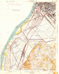
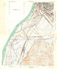
1934 Map of Cahokia
USGS Topo · Published 1934About this map
The industrial and riverfront landscape of Monsanto and Cahokia dominates this 1934 survey, revealing the dense concentration of infrastructure along the Mississippi River. The map meticulously details a complex rail network serving the American Bottoms, including the Terminal Railroad Association and the Missouri Pacific Railroad, which converge at the sprawling yards of Dupo and Valley Junction. This era of development is juxtaposed with the natural topography of the floodplain, where features like Lily Lake, Labras Lake, and the winding Cahokia Slough remain visible amidst the growing industrial footprint.
Find a feature on this map
57 named features on this map. Tap any name to fly to it.
Don’t see what you’re looking for? This feature index may not catch every label — zoom into the map to look around manually.
Map Details
Editions of this 1934 Cahokia Map
2 editions found
Other maps of this area

1888 · St. Louis
USGS Topo · 1:62,500

1910 · Waterloo
USGS Topo · 1:62,500

1912 · Kimmswick
USGS Topo · 1:62,500

1913 · Waterloo
USGS Topo · 1:62,500

1916 · Kimmswick
USGS Topo · 1:62,500

1931 · French Village
USGS Topo · 1:24,000

1933 · Granite City
USGS Topo · 1:24,000

1933 · Jefferson Barracks
USGS Topo · 1:24,000

1933 · Cahokia
USGS Topo · 1:24,000

1933 · Clayton
USGS Topo · 1:24,000