
1933 Map of Jefferson Barracks
USGS Topo · Published 1933About this map
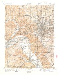
Jefferson Barracks serves as the focal point of the riverfront in this 1933 survey, with its military grounds containing the National Cem, Veterans Hospital, and designated infantry woods. The landscape is a complex mix of burgeoning suburban settlements like Shrewsbury, Brentwood, and Affton PO Grevois Sta, interconnected by a dense network of major thoroughfares including Gravois Road and Lindbergh State Highway. Significant institutional presence is visible through the Kenrick Seminary, Eden Seminary, and numerous parochial schools such as Assumption Sch & Ch.
Find a feature on this map
81 named features on this map. Tap any name to fly to it.
Don’t see what you’re looking for? This feature index may not catch every label — zoom into the map to look around manually.
Map Details
Editions of this 1933 Jefferson Barracks Map
This is the sole edition of this map. No revisions or reprints were ever made.
Other maps of this area

1888 · St. Louis
USGS Topo · 1:62,500

1910 · Waterloo
USGS Topo · 1:62,500

1912 · Kimmswick
USGS Topo · 1:62,500

1913 · Waterloo
USGS Topo · 1:62,500

1916 · Kimmswick
USGS Topo · 1:62,500

1933 · Creve Coeur
USGS Topo · 1:24,000

1933 · Granite City
USGS Topo · 1:24,000

1933 · Cahokia
USGS Topo · 1:24,000

1933 · Clayton
USGS Topo · 1:24,000
1933 · Kirkwood
USGS Topo · 1:24,000