1980s Maps of Chebanse, Illinois
Explore 3 historic maps of Chebanse from the 1980s. These maps offer a rare glimpse into what life looked like during the 1980s — showing old roads, neighborhoods, homes, and landmarks that have changed or disappeared over time.
Whether you're researching your family's past, planning a metal detecting trip, or studying how Chebanse's landscape evolved across the 1980s, these high-resolution maps are a powerful tool for exploring the history of this region.
- Focus on a specific era: All maps on this page are from the 1980s, giving you a focused view of this time period.
- See what’s changed: Compare century-old streets, trails, and buildings to today's modern landscape using overlays and satellite layers.
- Research with precision: Use these maps for genealogy, historical research, land use analysis, or educational projects.
- View, download, or print: Maps are fully viewable online in high resolution, and can be downloaded or printed for your own records.
Start exploring Chebanse's history through authentic maps from the 1980s. This is your window into the past.
Chebanse, IL maps
(3)- 1984 Map of Kankakee, 1985 Print
 1984 Kankakee1985 Print · USGSThe Illinois-Indiana borderlands appear here in the early eighties as a landscape of river-centered towns and vast managed wetlands. Genealogists and local historians can trace the grounds of the Kankakee State Hospital, the campus of Olivet Nazarene College, and the sprawling Beaver Lake Wildlife Refuge.
 - 1984 Map of Watseka, 1985 Print
 1984 Watseka1985 Print · USGSThe Illinois-Indiana borderlands thrived on a dense rail and river network during the mid-eighties. Genealogists and local historians can trace the foundations of rural life through landmarks like St Josephs College, the Iroquois Hospital, and towns like Milford and Beaverville.
 - 1986 Map of Clifton
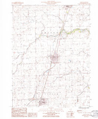 1986 Clifton1986 Print · USGSIroquois County at the mid-eighties shows a series of well-defined prairie settlements along the rail-and-highway corridor. Genealogists and local historians can trace the street grids of Clifton, Ashkum, and Chebanse while locating local landmarks like the Cem and Landing Strip.
End of results
Showing maps 1-3 of 3
Top cities near Chebanse
- Kankakee historical maps
- Bourbonnais historical maps
- Bradley historical maps
- Manteno historical maps
- Watseka historical maps
- Herscher historical maps
See more
Frequently asked questions
- What are the different types of historical maps available for Chebanse?
- What is the oldest map of Chebanse?
- Where can I purchase historical maps of Chebanse for my home or office?
- Where can I download high-res historical maps of Chebanse?
- Are there historical topographic maps available for Chebanse?
- Is there historical aerial imagery available for Chebanse?
- Where are historical maps of Chebanse sourced from?