1990s Maps of New Trier Township, Illinois
Explore 5 historic maps of New Trier Township from the 1990s. These maps offer a rare glimpse into what life looked like during the 1990s — showing old roads, neighborhoods, homes, and landmarks that have changed or disappeared over time.
Whether you're researching your family's past, planning a metal detecting trip, or studying how New Trier Township's landscape evolved across the 1990s, these high-resolution maps are a powerful tool for exploring the history of this region.
- Focus on a specific era: All maps on this page are from the 1990s, giving you a focused view of this time period.
- See what’s changed: Compare century-old streets, trails, and buildings to today's modern landscape using overlays and satellite layers.
- Research with precision: Use these maps for genealogy, historical research, land use analysis, or educational projects.
- View, download, or print: Maps are fully viewable online in high resolution, and can be downloaded or printed for your own records.
Start exploring New Trier Township's history through authentic maps from the 1990s. This is your window into the past.
New Trier Township, IL maps
(5)- 1993 Map of Highland Park
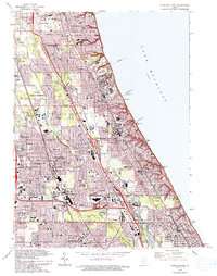 1993 Highland Park1993 Print · USGSThe North Shore suburbs flourish along the Lake Michigan coast in the early nineties as modern expressways intersect with historic rail lines. Genealogists and local historians can trace legacy sites like Fort Sheridan, Lake Forest College, and Deerfield Cem.
 - 1993 Map of Park Ridge
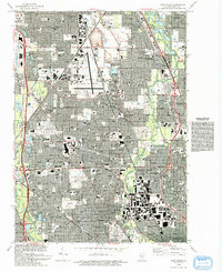 1993 Park Ridge1993 Print · USGSNorthern Cook County is shown in the early nineties as a fully developed suburban landscape centered on the Glenview Naval Air Station. Genealogists and historians can trace local institutions and burial sites including St Adalbert Cem and Ridgewood Cemetery.
 - 1993 Map of Evanston
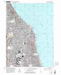
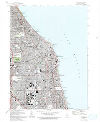 1993 Evanston1993 Print · USGSThe North Shore suburbs of Evanston and Wilmette are shown here during the early nineties, revealing a dense grid of lakefront neighborhoods and prestigious institutions. Genealogists and local historians can trace the grounds of Calvary Cemetery, Loyola University, and the unique Bahai Temple.
 - 1995 Map of Park Ridge, 1999 Print
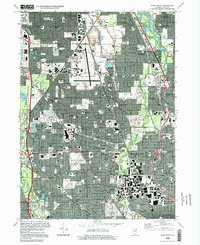 1995 Park Ridge1999 Print · USGSNorthwestern Cook County at the close of the century reveals a landscape of mature suburban expansion and major regional infrastructure. Genealogists and historians can trace family plots at Maryhill Cemetery or locate landmarks like the Naval Air Station and Hebrew Theological College.
 - 1995 Map of Evanston, 1999 Print
 1995 Evanston1999 Print · USGSThe North Shore's residential and institutional landscape is captured here in the late twentieth century. Genealogists and historians can trace the campuses of Northwestern University, the Bahai Temple, and the sprawling Calvary Cemetery.
End of results
Showing maps 1-5 of 5
Top cities near New Trier Township
- Chicago historical maps
- Waukegan historical maps
- Arlington Heights historical maps
- Evanston historical maps
- Skokie historical maps
- Des Plaines historical maps
See more
Top neighborhoods of New Trier Township
- Wilmette historical maps
- Winnetka historical maps
- Glencoe historical maps
- Kenilworth historical maps
- Welcome Plaza historical maps
- Indian Hill historical maps
Frequently asked questions
- What are the different types of historical maps available for New Trier Township?
- What is the oldest map of New Trier Township?
- Where can I purchase historical maps of New Trier Township for my home or office?
- Where can I download high-res historical maps of New Trier Township?
- Are there historical topographic maps available for New Trier Township?
- Is there historical aerial imagery available for New Trier Township?
- Where are historical maps of New Trier Township sourced from?