1970s Maps of Wapella, Illinois
Explore 1 historic maps of Wapella from the 1970s. These maps offer a rare glimpse into what life looked like during the 1970s — showing old roads, neighborhoods, homes, and landmarks that have changed or disappeared over time.
Whether you're researching your family's past, planning a metal detecting trip, or studying how Wapella's landscape evolved across the 1970s, these high-resolution maps are a powerful tool for exploring the history of this region.
- Focus on a specific era: All maps on this page are from the 1970s, giving you a focused view of this time period.
- See what’s changed: Compare century-old streets, trails, and buildings to today's modern landscape using overlays and satellite layers.
- Research with precision: Use these maps for genealogy, historical research, land use analysis, or educational projects.
- View, download, or print: Maps are fully viewable online in high resolution, and can be downloaded or printed for your own records.
Start exploring Wapella's history through authentic maps from the 1970s. This is your window into the past.
Wapella, IL maps
(1)- 1979 Map of Clinton, 1980 Print
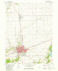 1979 Clinton1980 Print · USGSDe Witt County and the city of Clinton reached a modern peak of development in the late seventies as the local landscape balanced industry and recreation. Researchers can trace the Illinois Central Gulf rail lines or locate local landmarks like Woodlawn Cemetery, St John Sch, and Weldon Springs State Park.
End of results
Showing maps 1-1 of 1
Top cities near Wapella
- Bloomington historical maps
- Clinton historical maps
- Randolph historical maps
- Le Roy historical maps
- Heyworth historical maps
- Maroa historical maps
See more
Frequently asked questions
- What are the different types of historical maps available for Wapella?
- What is the oldest map of Wapella?
- Where can I purchase historical maps of Wapella for my home or office?
- Where can I download high-res historical maps of Wapella?
- Are there historical topographic maps available for Wapella?
- Is there historical aerial imagery available for Wapella?
- Where are historical maps of Wapella sourced from?