1940s Maps of Bingham, Illinois
Explore 2 historic maps of Bingham from the 1940s. These maps offer a rare glimpse into what life looked like during the 1940s — showing old roads, neighborhoods, homes, and landmarks that have changed or disappeared over time.
Whether you're researching your family's past, planning a metal detecting trip, or studying how Bingham's landscape evolved across the 1940s, these high-resolution maps are a powerful tool for exploring the history of this region.
- Focus on a specific era: All maps on this page are from the 1940s, giving you a focused view of this time period.
- See what’s changed: Compare century-old streets, trails, and buildings to today's modern landscape using overlays and satellite layers.
- Research with precision: Use these maps for genealogy, historical research, land use analysis, or educational projects.
- View, download, or print: Maps are fully viewable online in high resolution, and can be downloaded or printed for your own records.
Start exploring Bingham's history through authentic maps from the 1940s. This is your window into the past.
Bingham, IL maps
(2)- 1944 Map of Ramsey, 1976 Print
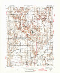 1944 Ramsey1976 Print · USGSFayette County communities like Ramsey and Bingham thrive along the intersection of the Illinois Central and other major rail lines during the 1940s. Genealogists can trace family roots through numerous rural landmarks like Bayle City P O, Halford Chapel, and Hoffman Cem.
 - 1946 Map of Ramsey
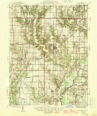 1946 Ramsey1946 Print · USGSCentral Illinois rail-and-river life thrives mid-century as the Kaskaskia River winds past a dense network of country schoolhouses. Genealogists and local historians can trace family roots at Shed Cem, Bayle City P O, and the Illinois State Penal Farm.2 unique versions available
End of results
Showing maps 1-2 of 2
Top cities near Bingham
- Greenville historical maps
- Vandalia historical maps
- Nokomis historical maps
- Ramsey historical maps
- Witt historical maps
- Coffeen historical maps
See more
Frequently asked questions
- What are the different types of historical maps available for Bingham?
- What is the oldest map of Bingham?
- Where can I purchase historical maps of Bingham for my home or office?
- Where can I download high-res historical maps of Bingham?
- Are there historical topographic maps available for Bingham?
- Is there historical aerial imagery available for Bingham?
- Where are historical maps of Bingham sourced from?