Old Maps of Jasper County, Illinois
Explore 127 old maps of Jasper County, spanning from 1910 to today. These high-resolution historic maps reveal how streets, neighborhoods, landmarks, and natural features evolved over time — perfect for genealogy, metal detecting, research, and local history exploration.
What you can do with these maps:
- See how Jasper County changed over time: Compare historical maps to modern-day views to trace roads, homesites, rail lines & more.
- View detailed metadata: Each map includes creators, publishers, year, scale, and archive source.
- Overlay maps with satellite & LiDAR: Visualize the past alongside modern tools to explore terrain & human change.
- Trusted historical sources: Maps sourced from the USGS, Library of Congress, and other archives.
- Access maps your way: View online, download high-res files, or order prints for personal or research use.
Start exploring old maps of Jasper County to uncover forgotten places, hidden landmarks, and the deep history beneath your feet.
Jasper County, IL maps
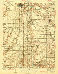
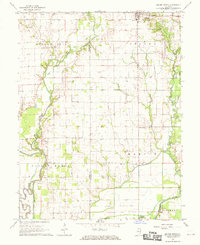
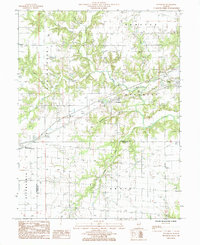
(127)- 1910 Map of Hardinville
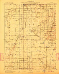 1910 Hardinville1910 Print · USGSSoutheastern Illinois at the start of the century reveals a landscape defined by the Embarrass River and early oil exploration. Genealogists can trace family roots through numerous local landmarks like Oil Center, Lucky Ford Ferry, and the Mann School.2 unique versions available
 - 1940 Map of Greenup, 1958 Print
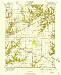
 1940 Greenup1958 Print · USGSCumberland and Jasper Counties are shown in detail as they appeared just before the war, dominated by the winding valley of the Embarrass River. Genealogists can trace dozens of country schools and churches, including Scotch Chapel Sch, Hazel Dell, and Washington Cem.2 unique versions available
 - 1941 Map of Newton, 1972 Print
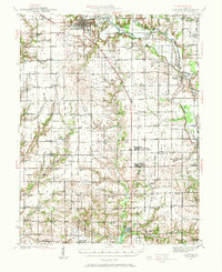 1941 Newton1972 Print · USGSJasper and Richland counties appear here during the early 1940s, showing a landscape of river-valley farms and small rail towns. Genealogists can trace family footprints through dozens of rural landmarks like Onion Prairie Sch, Bethel Cem, and Willow Hill.
 - 1943 Map of Greenup
 1943 Greenup1943 Print · USGSCumberland and Jasper counties are captured here in the early 1940s, highlighting a landscape defined by the Embarrass River and the historic National Road. Researchers can locate dozens of rural schools and family landmarks, from Hunt City to the Washington Cem and Wade Sch.2 unique versions available
 - 1943 Map of Newton
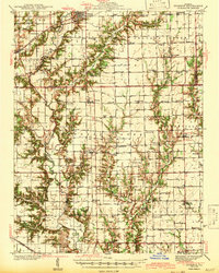
 1943 Newton1943 Print · USGSJasper and Richland counties are captured here in the early 1940s, showing a landscape defined by the Embarrass River and the Illinois Central railroad. Genealogists can locate dozens of country schools and churches, from Brush College Sch to Shiloh Ch.2 unique versions available
 - 1953 Map of Teutopolis, 1955 Print
 1953 Teutopolis1955 Print · USGSMid-century Effingham County and its neighbors are documented here during a period of agricultural stability and rail-line prominence. Genealogists can locate family landmarks including Elliottstown, Lillyville, and rural schools like Plain Tree Sch.2 unique versions available
 - 1953 Map of Sailor Springs, 1955 Print
 1953 Sailor Springs1955 Print · USGSSoutheast Illinois farmland at the start of the fifties reveals a landscape of tight-knit rural precincts and family homesteads. Genealogists can trace family names through dozens of landmarks like Shouse Chapel, Bethsaida Cem, and the Little Grove Sch.2 unique versions available
 - 1953 Map of Indianapolis, 1965 Print
 1953 Indianapolis1965 Print · USGSCentral Indiana and the Illinois borderlands are captured in the mid-sixties, showing the growth of Indianapolis and its industrial rail corridors. Genealogists and historians can trace the development of outlying towns like Zionsville or Beech Grove and find landmarks such as Atterbury AAF and Turkey Run State Park.4 unique versions available
 - 1956 Map of Indianapolis
 1956 Indianapolis1956 Print · USGSCentral Indiana in the mid-fifties is captured during a period of industrial growth and military presence. Genealogists and historians can trace the rail networks of the New York Central or locate regional landmarks like Fort Benjamin Harrison and Camp Atterbury.
 - 1956 Map of Annapolis, 1957 Print
 1956 Annapolis1957 Print · USGSSoutheast Illinois in the mid-1950s remains a landscape of tightly knit rural hamlets and creek-side farms. Genealogists can trace family footprints across dozens of country landmarks like Moonshine, Porterville (Eaton PO), and Backbone Cem.2 unique versions available
 - 1956 Map of Vincennes, 1967 Print
 1956 Vincennes1967 Print · USGSSouthern Indiana and the Illinois borderlands are captured here in the mid-fifties, showing the region's dense network of river towns and rail lines. Researchers can trace historic river crossings along the Wabash River or locate landmarks like Wyandotte Cave and Lincoln State Park.4 unique versions available
 - 1957 Map of Indianapolis
 1957 Indianapolis1957 Print · USGSCentral Indiana in the mid-fifties is captured here as a crossroads of major rail lines and nascent federal highways. Genealogists and historians can trace family-named ridges like Poplar Ridge or locate strategic sites like Camp Atterbury and Speedway.2 unique versions available
 - 1957 Map of Vincennes
 1957 Vincennes1957 Print · USGSSouthwest Indiana and the Illinois borderlands come alive in the late 1950s, a period of heavy rail traffic and expanding state forests. Genealogists and historians can trace the riverfronts and rail lines of Vincennes, New Harmony, and the vast Crane Naval Ammunition Depot.
 - 1958 Map of Vincennes
 1958 Vincennes1958 Print · USGSSouthern Indiana and the Illinois borderlands are captured during a mid-century period of heavy rail traffic and military activity. Researchers can trace the sprawling bounds of the Crane Naval Ammunition Depot or locate historic settlements like New Harmony and French Lick.2 unique versions available
 - 1958 Map of Decatur, 1971 Print
 1958 Decatur1971 Print · USGSCentral Illinois in the mid-twentieth century shows a landscape defined by industrial rail hubs and the creation of large reservoirs. Researchers can trace historic corridors like the Penn Central or locate landmarks such as Lincoln Log Cabin State Park and Lake Springfield.3 unique versions available
 - 1958 Map of Belleville, 1973 Print
 1958 Belleville1973 Print · USGSSouthern Illinois during the mid-twentieth century reveals a landscape of industrial growth and massive new reservoirs. Genealogists and historians can trace the paths of the Illinois Central RR through towns like Centralia or locate landmarks such as Emerald Mound and the Looking Glass Prairie.3 unique versions available
 - 1961 Map of Decatur
 1961 Decatur1961 Print · USGSCentral Illinois in the late fifties was a bustling corridor of rail lines and prairie commerce centered on the state capital. Genealogists and historians can trace the intricate connections between Springfield, Decatur, and dozens of smaller settlements like Nokomis and Arcola.2 unique versions available
 - 1962 Map of Belleville
 1962 Belleville1962 Print · USGSSouthern Illinois in the late fifties reveals a landscape of industrial growth and ancient landmarks before the full expansion of the interstate system. Genealogists can trace family names and rural post offices near Centralia, Salem, and the historic Monks Mound.
 - 1962 Map of Indianapolis
 1962 Indianapolis1962 Print · USGSCentral Indiana and the Illinois borderlands are captured here in the early sixties, showing the region's dense rail networks and growing urban centers. Genealogists and historians can locate family-named landmarks and institutions like Crown Hill Cem, Indiana University, and the Indianapolis Motor Speedway.
 - 1968 Map of Oblong South, 1970 Print
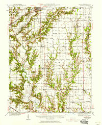
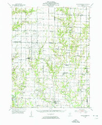
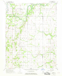
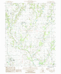
 1968 Oblong South1970 Print · USGSJasper and Crawford County at the end of the sixties reveal a rural landscape defined by the winding North Fork Embarras River and an active oil industry. Genealogists can locate family landmarks such as Miller Cem, Seed Chapel, and the St Valentine Ch Cem.2 unique versions available
 - 1968 Map of Landes, 1970 Print
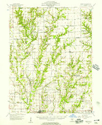
 1968 Landes1970 Print · USGSRichland and Jasper counties in the late sixties remain a patchwork of small townships and rural parishes. Family historians can trace local roots through numerous country landmarks like South Bend Cem, St Joseph Sch, and the Amity settlement.
 - 1985 Map of Greenup
 1985 Greenup1985 Print · USGSCumberland County’s river-bottom farms and rail towns are captured here in the mid-1980s as the landscape shifts toward modern infrastructure. Researchers can trace family roots through the grids of Greenup, Jewett, and Hidalgo, or locate historical sites like the Fairground and Liberty Hill.
 - 1985 Map of Latona
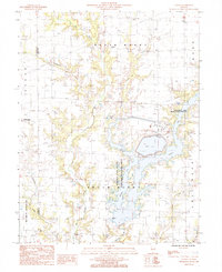 1985 Latona1985 Print · USGSJasper County in the 1980s shows a unique mix of heavy energy infrastructure and dedicated wildlife conservation. Researchers can trace the development of Newton Lake near the Power Plant and locate rural hubs like Latona and Winterrowd.
 - 1985 Map of Woodbury
 1985 Woodbury1985 Print · USGSCumberland County at the mid-eighties shows a landscape defined by the Illinois Central Gulf railroad and small rural hubs. Local researchers can trace the old town sites of Woodbury and Roslyn or locate secluded cemeteries near the Jasper County line.
 - 1985 Map of Sailor Springs
 1985 Sailor Springs1985 Print · USGSThe rural borderlands of Clay and Jasper counties are captured here in the mid-1980s, centered on the village of Sailor Springs. Genealogists and local historians can trace the creek-side settlements of Ingraham and Wendelin or locate family plots near Big Muddy Creek.
Showing maps 1-25 of 127
Top cities of Jasper County
- Newton historical maps
- Hunt City historical maps
- Willow Hill historical maps
- Hidalgo historical maps
- Wheeler historical maps
- Yale historical maps
See more
Frequently asked questions
- What are the different types of historical maps available for Jasper County?
- What is the oldest map of Jasper County?
- Where can I purchase historical maps of Jasper County for my home or office?
- Where can I download high-res historical maps of Jasper County?
- Are there historical topographic maps available for Jasper County?
- Is there historical aerial imagery available for Jasper County?
- Where are historical maps of Jasper County sourced from?