1910s Maps of Scales Mound Historic District, Scales Mound
Explore 2 historic maps of Scales Mound Historic District from the 1910s. These maps offer a rare glimpse into what life looked like during the 1910s — showing old roads, neighborhoods, homes, and landmarks that have changed or disappeared over time.
Whether you're researching your family's past, planning a metal detecting trip, or studying how Scales Mound Historic District's landscape evolved across the 1910s, these high-resolution maps are a powerful tool for exploring the history of this region.
- Focus on a specific era: All maps on this page are from the 1910s, giving you a focused view of this time period.
- See what’s changed: Compare century-old streets, trails, and buildings to today's modern landscape using overlays and satellite layers.
- Research with precision: Use these maps for genealogy, historical research, land use analysis, or educational projects.
- View, download, or print: Maps are fully viewable online in high resolution, and can be downloaded or printed for your own records.
Start exploring Scales Mound Historic District's history through authentic maps from the 1910s. This is your window into the past.
Scales Mound Historic District, Scales Mound maps
(2)- 1911 Map of Galena, 1953 Print
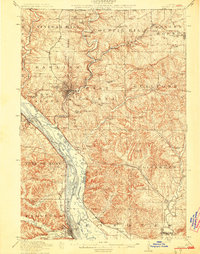
 1911 Galena1953 Print · USGSBefore the decline of the local lead industry, this area was a hub of mining and river commerce. Genealogists can trace family names through dozens of rural schools and mines like Blackjack Mine, or locate long-lost river crossings like Gears Ferry.3 unique versions available
 - 1913 Map of Galena
 1913 Galena1913 Print · USGSThe mining and river districts of Jo Daviess County are captured here just before the First World War. Genealogists and researchers can locate family-named landmarks like Horseshoe Mound, local schools such as Miners School, and industrial sites like the Hoskin Mine.3 unique versions available
End of results
Showing maps 1-2 of 2
Frequently asked questions
- What are the different types of historical maps available for Scales Mound Historic District?
- What is the oldest map of Scales Mound Historic District?
- Where can I purchase historical maps of Scales Mound Historic District for my home or office?
- Where can I download high-res historical maps of Scales Mound Historic District?
- Are there historical topographic maps available for Scales Mound Historic District?
- Is there historical aerial imagery available for Scales Mound Historic District?
- Where are historical maps of Scales Mound Historic District sourced from?