1940s Maps of Centerville, Illinois
Explore 2 historic maps of Centerville from the 1940s. These maps offer a rare glimpse into what life looked like during the 1940s — showing old roads, neighborhoods, homes, and landmarks that have changed or disappeared over time.
Whether you're researching your family's past, planning a metal detecting trip, or studying how Centerville's landscape evolved across the 1940s, these high-resolution maps are a powerful tool for exploring the history of this region.
- Focus on a specific era: All maps on this page are from the 1940s, giving you a focused view of this time period.
- See what’s changed: Compare century-old streets, trails, and buildings to today's modern landscape using overlays and satellite layers.
- Research with precision: Use these maps for genealogy, historical research, land use analysis, or educational projects.
- View, download, or print: Maps are fully viewable online in high resolution, and can be downloaded or printed for your own records.
Start exploring Centerville's history through authentic maps from the 1940s. This is your window into the past.
Centerville, IL maps
(2)- 1940 Map of Galva, 1957 Print
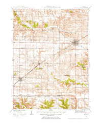 1940 Galva1957 Print · USGSHenry and Knox counties are captured here as a bustling railroad landscape in the early 1940s. Genealogists can trace the rural school and church networks of the era, from the uniquely named Swamp College Sch to the settlement at Bishop Hill.2 unique versions available
 - 1944 Map of Galva
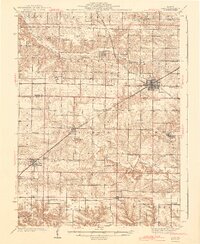 1944 Galva1944 Print · USGSNorthwestern Illinois farmland is captured in the 1940s as a thriving network of rail towns and country schools. Genealogists can locate family landmarks like Piatt Cem or trace the early layout of historic Bishop Hill and Galva.2 unique versions available
End of results
Showing maps 1-2 of 2
Top cities near Centerville
- Kewanee historical maps
- Knoxville historical maps
- Galva historical maps
- Cambridge historical maps
- Toulon historical maps
- Brimfield historical maps
See more
Frequently asked questions
- What are the different types of historical maps available for Centerville?
- What is the oldest map of Centerville?
- Where can I purchase historical maps of Centerville for my home or office?
- Where can I download high-res historical maps of Centerville?
- Are there historical topographic maps available for Centerville?
- Is there historical aerial imagery available for Centerville?
- Where are historical maps of Centerville sourced from?