1980s Maps of Pontiac Township, Illinois
Explore 5 historic maps of Pontiac Township from the 1980s. These maps offer a rare glimpse into what life looked like during the 1980s — showing old roads, neighborhoods, homes, and landmarks that have changed or disappeared over time.
Whether you're researching your family's past, planning a metal detecting trip, or studying how Pontiac Township's landscape evolved across the 1980s, these high-resolution maps are a powerful tool for exploring the history of this region.
- Focus on a specific era: All maps on this page are from the 1980s, giving you a focused view of this time period.
- See what’s changed: Compare century-old streets, trails, and buildings to today's modern landscape using overlays and satellite layers.
- Research with precision: Use these maps for genealogy, historical research, land use analysis, or educational projects.
- View, download, or print: Maps are fully viewable online in high resolution, and can be downloaded or printed for your own records.
Start exploring Pontiac Township's history through authentic maps from the 1980s. This is your window into the past.
Pontiac Township, IL maps
(5)- 1983 Map of Southeast Pontiac
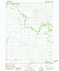 1983 Southeast Pontiac1983 Print · USGSLivingston County's agricultural heartland is documented here in the early eighties, showcasing a landscape of river-bend settlements and prairie townships. Local researchers can locate family-named cemeteries like Houder Cem and Patty Cem or trace rural aviation history at Ziller Landing Strip.
 - 1983 Map of Northwest Pontiac
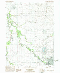 1983 Northwest Pontiac1983 Print · USGSNorthwest of the Livingston county seat in the early eighties, the prairie landscape is defined by the winding Vermilion River. Researchers can trace the Illinois Central Gulf rail line through Pontiac or locate rural landmarks like Zooks Cem and Esmen Ch.
 - 1983 Map of Southwest Pontiac
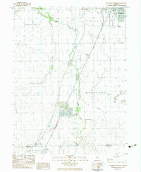 1983 Southwest Pontiac1983 Print · USGSLivingston County in the early eighties shows a landscape shaped by rail, aviation, and institutional history. Researchers can trace the grounds of the State Correctional Center or locate smaller sites like Ocoya and Payne Cem.
 - 1983 Map of Northeast Pontiac
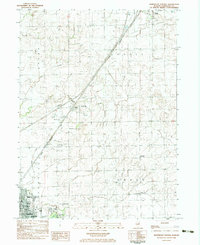 1983 Northeast Pontiac1983 Print · USGSLivingston County grain-farming country is shown here in the early eighties as the rail-and-road corridor between Pontiac and Odell remained vital. Researchers can locate vanished rural landmarks like the Owego Sch, the Schott Landing Strip, and the crossroads at Swygert.
 - 1985 Map of Fairbury
 1985 Fairbury1985 Print · USGSCentral Illinois in the mid-1980s reveals a landscape shaped by the Illinois Central Gulf rail network and the Vermilion River basin. Trace the roots of local communities from Fairbury to Pontiac, and locate landmarks like the State Correctional Center and High Chapel.2 unique versions available
End of results
Showing maps 1-5 of 5
Top cities near Pontiac Township
- Streator historical maps
- Pontiac historical maps
- Dwight historical maps
- Fairbury historical maps
- Lexington historical maps
- Chenoa historical maps
See more
Top neighborhoods of Pontiac Township
Frequently asked questions
- What are the different types of historical maps available for Pontiac Township?
- What is the oldest map of Pontiac Township?
- Where can I purchase historical maps of Pontiac Township for my home or office?
- Where can I download high-res historical maps of Pontiac Township?
- Are there historical topographic maps available for Pontiac Township?
- Is there historical aerial imagery available for Pontiac Township?
- Where are historical maps of Pontiac Township sourced from?