1990s Maps of McHenry County, Illinois
Explore 10 historic maps of McHenry County from the 1990s. These maps offer a rare glimpse into what life looked like during the 1990s — showing old roads, neighborhoods, homes, and landmarks that have changed or disappeared over time.
Whether you're researching your family's past, planning a metal detecting trip, or studying how McHenry County's landscape evolved across the 1990s, these high-resolution maps are a powerful tool for exploring the history of this region.
- Focus on a specific era: All maps on this page are from the 1990s, giving you a focused view of this time period.
- See what’s changed: Compare century-old streets, trails, and buildings to today's modern landscape using overlays and satellite layers.
- Research with precision: Use these maps for genealogy, historical research, land use analysis, or educational projects.
- View, download, or print: Maps are fully viewable online in high resolution, and can be downloaded or printed for your own records.
Start exploring McHenry County's history through authentic maps from the 1990s. This is your window into the past.
McHenry County, IL maps
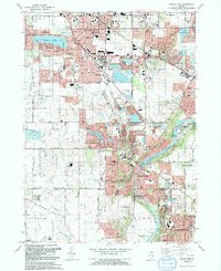
(10)- 1992 Map of Woodstock
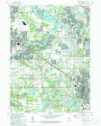
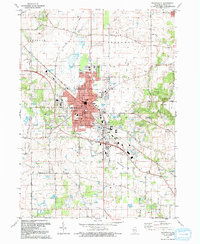 1992 Woodstock1992 Print · USGSWoodstock and McHenry County are shown in the early nineties as suburban expansion began to meet the region's agricultural roots. Genealogists can trace local legacies at Scandinavian Cem or locate community anchors like St Marys Sch & Ch and the historic Courthouse.2 unique versions available
 - 1992 Map of McHenry
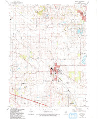
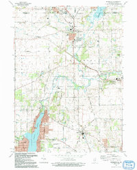
 1992 McHenry1992 Print · USGSMcHenry County in the early nineties shows a landscape of growing residential lakes and riverfront suburbs. Genealogists and researchers can locate family sites at St Marys Cem or Ostend Cem, and trace the path of the Chicago and North Western railroad.
 - 1992 Map of Hebron
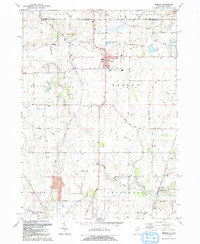 1992 Hebron1992 Print · USGSHebron and the surrounding farmland of McHenry County are shown here in the early 1990s, just as the region maintained its rural character against the state border. Researchers can trace family history at Linn-Hebron Cem or locate the old Old Railroad Grade and Galt Airport.2 unique versions available
 - 1992 Map of Huntley
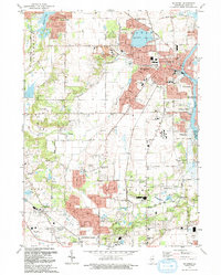
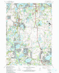
 1992 Huntley1992 Print · USGSNorthern Illinois at the start of the nineties reveals a landscape of growing towns and preserved prairies. Genealogists and historians can trace local landmarks like Mt Thabor Cem, the Chicago and North Western rail line, and the Township Hall.
 - 1992 Map of Crystal Lake
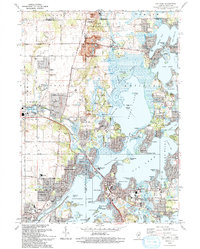
 1992 Crystal Lake1992 Print · USGSThe Fox River valley was rapidly transforming in the early nineties as residential growth expanded around its historic glacial lakes. Researchers can trace local lineage through Union Cemetery or explore established enclaves like Haegers Bend and Turner Camp.
 - 1992 Map of Richmond
 1992 Richmond1992 Print · USGSThe Illinois-Wisconsin borderlands come alive in the early nineties, showing the transition from rural crossroads to growing communities. Genealogists and historians can trace family sites like Washington Cem and schools in Richmond or Ringwood.
 - 1993 Map of Wauconda
 1993 Wauconda1993 Print · USGSThe Fox River and its glacial lakes defined the Lake County borderlands in the early nineties as residential growth expanded around traditional preserves. Genealogists can trace family names at Fisher Family Cem or locate the old Crown Sch and St Marys Chapel.
 - 1993 Map of Fox Lake
 1993 Fox Lake1993 Print · USGSThe Illinois-Wisconsin border country comes alive in this survey of the Chain O' Lakes during the early nineties. Genealogists and local historians can trace family-named sites like Wray-Imeson Cem or explore the transit history of the Chicago and North Western railroad.
 - 1993 Map of Barrington
 1993 Barrington1993 Print · USGSNorthern Illinois riverside towns and residential enclaves are shown in the early nineties as they expanded around the Fox River. Researchers can trace the rail corridor and locate White Cem, St Ann Sch, and Lake Barrington.
 - 1998 Map of Wauconda, 2003 Print
 1998 Wauconda2003 Print · USGSLake County and McHenry County communities are shown here at a peak of suburban growth in the late nineties. Genealogists and local historians can locate legacy sites like Fisher Family Cem, St Marys Chapel, and the Oak Knoll Landing Strip.
End of results
Showing maps 1-10 of 10
Top cities of McHenry County
- Crystal Lake historical maps
- Lake in the Hills historical maps
- McHenry historical maps
- Woodstock historical maps
- Cary historical maps
- Harvard historical maps
See more
Frequently asked questions
- What are the different types of historical maps available for McHenry County?
- What is the oldest map of McHenry County?
- Where can I purchase historical maps of McHenry County for my home or office?
- Where can I download high-res historical maps of McHenry County?
- Are there historical topographic maps available for McHenry County?
- Is there historical aerial imagery available for McHenry County?
- Where are historical maps of McHenry County sourced from?