1960s Maps of Crystal Lake, Illinois
Explore 6 historic maps of Crystal Lake from the 1960s. These maps offer a rare glimpse into what life looked like during the 1960s — showing old roads, neighborhoods, homes, and landmarks that have changed or disappeared over time.
Whether you're researching your family's past, planning a metal detecting trip, or studying how Crystal Lake's landscape evolved across the 1960s, these high-resolution maps are a powerful tool for exploring the history of this region.
- Focus on a specific era: All maps on this page are from the 1960s, giving you a focused view of this time period.
- See what’s changed: Compare century-old streets, trails, and buildings to today's modern landscape using overlays and satellite layers.
- Research with precision: Use these maps for genealogy, historical research, land use analysis, or educational projects.
- View, download, or print: Maps are fully viewable online in high resolution, and can be downloaded or printed for your own records.
Start exploring Crystal Lake's history through authentic maps from the 1960s. This is your window into the past.
Crystal Lake, IL maps
(6)- 1962 Map of Huntley, 1964 Print
 1962 Huntley1964 Print · USGSHuntley and its surrounding townships are captured in the early sixties as the rural landscape began to meet the path of the new tollway. Researchers can locate family sites near Grange Hall, St Marys Cem, and the small siding at Coyne.
 - 1962 Map of Crystal Lake, 1964 Print
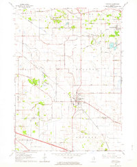
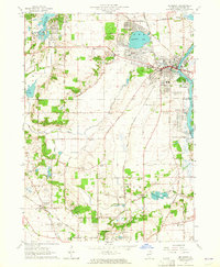
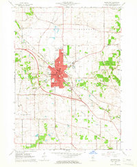
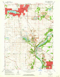 1962 Crystal Lake1964 Print · USGSCrystal Lake and the Fox River valley are captured in the early sixties as suburban development began to fill the landscape between established towns. Researchers can trace mid-century growth through local landmarks like St Marys Seminary, the Crystal Lake Airport, and Union Cem.4 unique versions available
 - 1962 Map of Elgin, 1965 Print
 1962 Elgin1965 Print · USGSThe Fox River valley and the expanding Chicago suburbs are captured here in the early sixties. Genealogists and local historians can trace legacy sites like Washington Church Cemetery, the Elgin Academy, and the State Hospital Cemetery.
 - 1963 Map of Rockford
 1963 Rockford1963 Print · USGSThe mid-century industrial corridor along the Rock River is shown here during a period of rapid post-war growth. Researchers can trace the extensive rail lines of the Chicago and North Western or locate local landmarks like the Rockford Ordnance Depot and Holy Hill.
 - 1963 Map of McHenry, 1964 Print
 1963 McHenry1964 Print · USGSMcHenry County at the start of the 1960s shows a landscape of lakeside settlements and river-valley farms. Trace family roots at Holcombville Cem or Ridgefield Cem, and locate early landmarks like St Joseph Seminary and the Chicago and North Western rail line.3 unique versions available
 - 1963 Map of Woodstock, 1964 Print
 1963 Woodstock1964 Print · USGSWoodstock and the surrounding McHenry County countryside are captured in the early sixties as the city expanded along the Chicago and North Western tracks. Researchers can locate vanished rural landmarks and family burial sites like Scandinavian Cem, Olson Cem, and the Westwood Sch.3 unique versions available
End of results
Showing maps 1-6 of 6
Top cities near Crystal Lake
- Elgin historical maps
- Schaumburg historical maps
- Hoffman Estates historical maps
- Bartlett historical maps
- Hanover Park historical maps
- Streamwood historical maps
See more
Top neighborhoods of Crystal Lake
- North Shore historical maps
- Crystal Vista historical maps
- Oakbrook Estates Mobile Home Park historical maps
Frequently asked questions
- What are the different types of historical maps available for Crystal Lake?
- What is the oldest map of Crystal Lake?
- Where can I purchase historical maps of Crystal Lake for my home or office?
- Where can I download high-res historical maps of Crystal Lake?
- Are there historical topographic maps available for Crystal Lake?
- Is there historical aerial imagery available for Crystal Lake?
- Where are historical maps of Crystal Lake sourced from?