1970s Maps of Durand Township, Illinois
Explore 2 historic maps of Durand Township from the 1970s. These maps offer a rare glimpse into what life looked like during the 1970s — showing old roads, neighborhoods, homes, and landmarks that have changed or disappeared over time.
Whether you're researching your family's past, planning a metal detecting trip, or studying how Durand Township's landscape evolved across the 1970s, these high-resolution maps are a powerful tool for exploring the history of this region.
- Focus on a specific era: All maps on this page are from the 1970s, giving you a focused view of this time period.
- See what’s changed: Compare century-old streets, trails, and buildings to today's modern landscape using overlays and satellite layers.
- Research with precision: Use these maps for genealogy, historical research, land use analysis, or educational projects.
- View, download, or print: Maps are fully viewable online in high resolution, and can be downloaded or printed for your own records.
Start exploring Durand Township's history through authentic maps from the 1970s. This is your window into the past.
Durand Township, IL maps
(2)- 1971 Map of Durand, 1974 Print
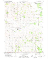 1971 Durand1974 Print · USGSNorthwestern Winnebago County in the early seventies remains a region of steady rail commerce and family farming. Genealogists and researchers can trace the locations of St Marys Cem, McCartney Airfield, and the old Farm School.
 - 1971 Map of Davis, 1974 Print
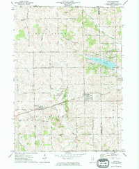 1971 Davis1974 Print · USGSNorthern Illinois at the start of the seventies reveals a landscape of growing lake communities and rail-side villages. Genealogists can trace family names through Pioneers Cem, St Pauls Ch, and the rural Farm School.
End of results
Showing maps 1-2 of 2
Top cities near Durand Township
- Rockford historical maps
- Winnebago historical maps
- Brodhead historical maps
- Pecatonica historical maps
- Town of Newark historical maps
- Seward historical maps
See more
Top neighborhoods of Durand Township
Frequently asked questions
- What are the different types of historical maps available for Durand Township?
- What is the oldest map of Durand Township?
- Where can I purchase historical maps of Durand Township for my home or office?
- Where can I download high-res historical maps of Durand Township?
- Are there historical topographic maps available for Durand Township?
- Is there historical aerial imagery available for Durand Township?
- Where are historical maps of Durand Township sourced from?