1930s Maps of Kappa, Illinois
Explore 2 historic maps of Kappa from the 1930s. These maps offer a rare glimpse into what life looked like during the 1930s — showing old roads, neighborhoods, homes, and landmarks that have changed or disappeared over time.
Whether you're researching your family's past, planning a metal detecting trip, or studying how Kappa's landscape evolved across the 1930s, these high-resolution maps are a powerful tool for exploring the history of this region.
- Focus on a specific era: All maps on this page are from the 1930s, giving you a focused view of this time period.
- See what’s changed: Compare century-old streets, trails, and buildings to today's modern landscape using overlays and satellite layers.
- Research with precision: Use these maps for genealogy, historical research, land use analysis, or educational projects.
- View, download, or print: Maps are fully viewable online in high resolution, and can be downloaded or printed for your own records.
Start exploring Kappa's history through authentic maps from the 1930s. This is your window into the past.
Kappa, IL maps
(2)- 1930 Map of Danvers
 1930 Danvers1930 Print · USGSCentral Illinois farming communities are frozen in time just before the Depression, showing a landscape defined by the Mackinaw River and thriving rail lines. Genealogists can locate family-named schoolhouses like Strubhar Sch and early religious centers like East White Oak Ch.2 unique versions available
 - 1930 Map of Normal
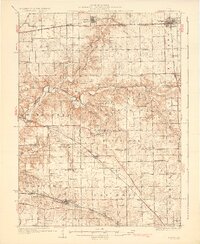
 1930 Normal1930 Print · USGSMcLean County is captured here in the late twenties, showing a rural landscape defined by rail lines and a school in nearly every section. Genealogists can locate specific landmarks like the Little Red Sch, the Town Hall in Money Creek, and the old rail corridors of the Chicago and Alton.2 unique versions available
End of results
Showing maps 1-2 of 2
Top cities near Kappa
- Bloomington historical maps
- Normal historical maps
- El Paso historical maps
- Minonk historical maps
- Roanoke historical maps
- Lexington historical maps
See more
Frequently asked questions
- What are the different types of historical maps available for Kappa?
- What is the oldest map of Kappa?
- Where can I purchase historical maps of Kappa for my home or office?
- Where can I download high-res historical maps of Kappa?
- Are there historical topographic maps available for Kappa?
- Is there historical aerial imagery available for Kappa?
- Where are historical maps of Kappa sourced from?