Old Maps of Columbus, Indiana
Explore 45 old maps of Columbus, spanning from 1942 to today. These high-resolution historic maps reveal how streets, neighborhoods, landmarks, and natural features evolved over time — perfect for genealogy, metal detecting, research, and local history exploration.
What you can do with these maps:
- See how Columbus changed over time: Compare historical maps to modern-day views to trace roads, homesites, rail lines & more.
- View detailed metadata: Each map includes creators, publishers, year, scale, and archive source.
- Overlay maps with satellite & LiDAR: Visualize the past alongside modern tools to explore terrain & human change.
- Trusted historical sources: Maps sourced from the USGS, Library of Congress, and other archives.
- Access maps your way: View online, download high-res files, or order prints for personal or research use.
Start exploring old maps of Columbus to uncover forgotten places, hidden landmarks, and the deep history beneath your feet.
Columbus, IN maps
(45)- 1942 Map of Franklin
 1942 Franklin1942 Print · USGSCentral Indiana during the early years of the war shows a landscape of established rail towns and growing military installations. Genealogists can trace family names across small settlements like Nineveh, Bean Blossom, and Helmsburg, or locate the Indiana University Observatory.
 - 1942 Map of Columbus
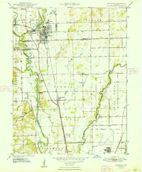
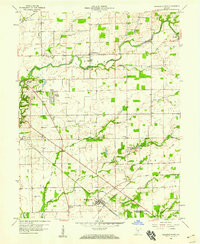
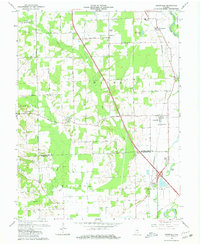
 1942 Columbus1942 Print · USGSBartholomew and Shelby counties are shown during the early years of the war, as military installations and rail lines reshaped the rural Indiana landscape. Genealogists can trace family-named sites and established communities like St Louis Crossing, Hope, and the sprawling Camp Atterbury.
 - 1948 Map of Edinburg
 1948 Edinburg1948 Print · USGSThe Driftwood River valley transitions from agricultural heartland to a significant military installation in the late 1940s. Genealogists can trace family names at Rest Haven Cem and Treadway Cem or locate the rural Old Union Ch near the banks of Big Slough.
 - 1948 Map of New Bellsville
 1948 New Bellsville1948 Print · USGSBartholomew and Brown County rural life and military expansion meet in the late 1940s. Genealogists and local historians can trace schoolhouse sites like Sprague Sch and family burial grounds including Dobbs Cem and Haislup Cem.
 - 1950 Map of Edinburg
 1950 Edinburg1950 Print · USGSMid-century Shelby and Bartholomew Counties are captured here as the military presence at Atterbury meets a deeply rooted farming landscape. Researchers can locate dozens of country landmarks like Jollity Church, Tennehill Bridge, and the Shelby Township School.2 unique versions available
 - 1953 Map of Cincinnati, 1965 Print
 1953 Cincinnati1965 Print · USGSThe Ohio River valley and the industrial heartland of Indiana and Ohio are captured here during the mid-century peak of rail and river commerce. Genealogists and historians can trace connections between Cincinnati and outlying military sites like Camp Atterbury and Bakalar AFB.3 unique versions available
 - 1953 Map of Indianapolis, 1965 Print
 1953 Indianapolis1965 Print · USGSCentral Indiana and the Illinois borderlands are captured in the mid-sixties, showing the growth of Indianapolis and its industrial rail corridors. Genealogists and historians can trace the development of outlying towns like Zionsville or Beech Grove and find landmarks such as Atterbury AAF and Turkey Run State Park.4 unique versions available
 - 1956 Map of Indianapolis
 1956 Indianapolis1956 Print · USGSCentral Indiana in the mid-fifties is captured during a period of industrial growth and military presence. Genealogists and historians can trace the rail networks of the New York Central or locate regional landmarks like Fort Benjamin Harrison and Camp Atterbury.
 - 1957 Map of Indianapolis
 1957 Indianapolis1957 Print · USGSCentral Indiana in the mid-fifties is captured here as a crossroads of major rail lines and nascent federal highways. Genealogists and historians can trace family-named ridges like Poplar Ridge or locate strategic sites like Camp Atterbury and Speedway.2 unique versions available
 - 1957 Map of Cincinnati
 1957 Cincinnati1957 Print · USGSThe Ohio River valley and its surrounding highlands thrived during the mid-fifties industrial peak, centered on the bustling Cincinnati and Dayton metropolitan hubs. Researchers can trace the extensive rail networks and military sites like Wright-Patterson AFB and Camp Atterbury.
 - 1957 Map of Jonesville, 1958 Print
 1957 Jonesville1958 Print · USGSMid-century Bartholomew County and Jackson County life revolves around the East Fork White River and the local rail line. Genealogists and historians can trace the foundations of Jonesville and Waynesville or locate landmarks like Walker Chapel and St Johns Sch Cem.
 - 1958 Map of Columbus, 1959 Print
 1958 Columbus1959 Print · USGSBartholomew County comes into focus in the late fifties as its river-and-rail hub expands toward the surrounding prairies. Genealogists and historians can trace the urban footprint of Columbus out to rural landmarks like Mt Pleasant Ch, Daugherty Cem, and the Booth-Setser Sch.
 - 1958 Map of Elizabethtown, 1959 Print
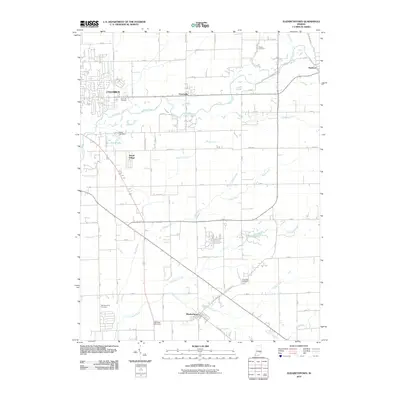
 1958 Elizabethtown1959 Print · USGSThe Bartholomew County countryside is captured here in the late fifties as a bustling rail crossroads. Genealogists can trace family names through New Harmony Cemetery and St Paul’s Church or locate the hub where the PENNSYLVANIA railroad meets the Milwaukee line.4 unique versions available
 - 1961 Map of Edinburg, 1964 Print
 1961 Edinburg1964 Print · USGSThe river forks south of Indianapolis come alive in this early 1960s survey of the Driftwood and Flatrock valleys. Genealogists can locate family sites at Tannehill Cem and Old Bethel Ch, or trace the legacy of the Tannehill Covered Bridge.5 unique versions available
 - 1962 Map of Indianapolis
 1962 Indianapolis1962 Print · USGSCentral Indiana and the Illinois borderlands are captured here in the early sixties, showing the region's dense rail networks and growing urban centers. Genealogists and historians can locate family-named landmarks and institutions like Crown Hill Cem, Indiana University, and the Indianapolis Motor Speedway.
 - 1962 Map of New Bellsville, 1964 Print
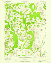
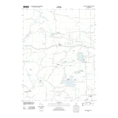
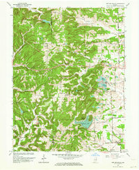 1962 New Bellsville1964 Print · USGSBartholomew County and the eastern edge of Brown County are shown in the early sixties as recreational lakes and military lands reshaped the rural landscape. Researchers can locate family cemeteries like Haislup Cem and Dobbs Cem, or trace early settlements from New Bellsville to Ogilville.5 unique versions available
 - 1962 Map of Columbus, 1964 Print
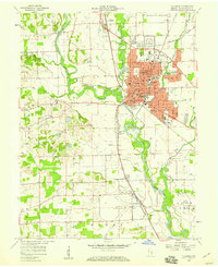
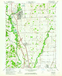
 1962 Columbus1964 Print · USGSBartholomew County experiences a period of significant mid-century growth as the urban center of Columbus expands toward Bakalar Air Force Base. Genealogists and local historians can locate several family burial sites including Carter Cem and trace the path of the Pennsylvania railroad past Walesboro.6 unique versions available
 - 1962 Map of Jonesville, 1965 Print
 1962 Jonesville1965 Print · USGSBartholomew and Jackson Counties are captured in the early sixties as rural life centered on the river forks and the rail line. Genealogists can locate old homesteads near Walker Chapel, the Township Sch, and the riverside cluster at Little Acre.5 unique versions available
 - 1986 Map of Greensburg
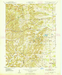
 1986 Greensburg1986 Print · USGSSoutheastern Indiana in the mid-eighties shows a balance of growing industrial centers and deeply rooted rural communities. Family historians can trace landmarks like the Highland Center School, South Park Cemetery, and the Bartholomew County Courthouse among the river forks.2 unique versions available
 - 1986 Map of Bloomington
 1986 Bloomington1986 Print · USGSMid-century development and vast conservation areas define south-central Indiana during the eighties. Genealogists and historians can trace family roots through numerous landmarks like Beanblossom Cem, New Unionville Church, and the historic corridors of the Indiana RR.3 unique versions available
 - 2010 Map of Columbus, 2010 Print
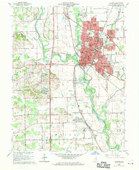
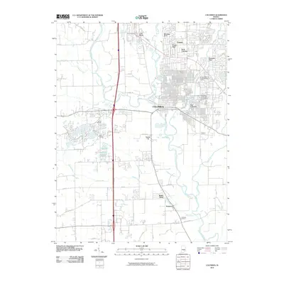 2010 Columbus2010 Print · USGSCovers Columbus, including Garden City, Bethel Village, and other nearby areas
 - 2010 Map of Jonesville, 2010 Print
 2010 Jonesville2010 Print · USGSCovers Columbus, including Jonesville, Peters Switch, and other nearby areas
 - 2010 Map of Edinburgh, 2010 Print
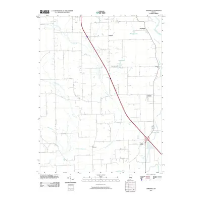
 2010 Edinburgh2010 Print · USGSCovers Columbus, including Pleasant View Village, Cuba, and other nearby areas
 - 2010 Map of Elizabethtown, 2010 Print
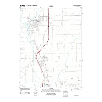
 2010 Elizabethtown2010 Print · USGSCovers Columbus, including Elizabethtown, Jewell Village, and other nearby areas
 - 2010 Map of New Bellsville, 2010 Print
 2010 New Bellsville2010 Print · USGSCovers Columbus, including Grandview Lake, Stony Lonesome, and other nearby areas
Showing maps 1-25 of 45
Top cities near Columbus
- Seymour historical maps
- Nineveh historical maps
- Hope historical maps
- Princes Lakes historical maps
- Trafalgar historical maps
- Elizabethtown historical maps
See more
Top neighborhoods of Columbus
- Corn Brook historical maps
- Everroad Park historical maps
- North Columbus historical maps
- Parkside historical maps
- Riverview Acres historical maps
- Flat Rock Park historical maps
See more
Frequently asked questions
- What are the different types of historical maps available for Columbus?
- What is the oldest map of Columbus?
- Where can I purchase historical maps of Columbus for my home or office?
- Where can I download high-res historical maps of Columbus?
- Are there historical topographic maps available for Columbus?
- Is there historical aerial imagery available for Columbus?
- Where are historical maps of Columbus sourced from?