Old Maps of Boone County, Indiana
Explore 111 old maps of Boone County, spanning from 1952 to today. These high-resolution historic maps reveal how streets, neighborhoods, landmarks, and natural features evolved over time — perfect for genealogy, metal detecting, research, and local history exploration.
What you can do with these maps:
- See how Boone County changed over time: Compare historical maps to modern-day views to trace roads, homesites, rail lines & more.
- View detailed metadata: Each map includes creators, publishers, year, scale, and archive source.
- Overlay maps with satellite & LiDAR: Visualize the past alongside modern tools to explore terrain & human change.
- Trusted historical sources: Maps sourced from the USGS, Library of Congress, and other archives.
- Access maps your way: View online, download high-res files, or order prints for personal or research use.
Start exploring old maps of Boone County to uncover forgotten places, hidden landmarks, and the deep history beneath your feet.
Boone County, IN maps
(111)- 1952 Map of Carmel, 1953 Print
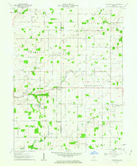
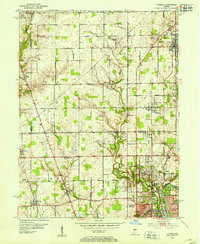 1952 Carmel1953 Print · USGSNorth of Indianapolis in the early 1950s, the landscape was a mix of quiet rural townships and new suburban communities. Genealogists can trace early homesteads near Eagle Village or locate historic markers like Poplar Ridge Cem and Clay Center Sch.
 - 1953 Map of Westfield, 1954 Print
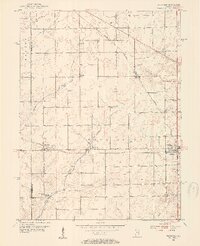 1953 Westfield1954 Print · USGSHamilton County agricultural life in the early fifties is preserved here, showing the rural rail junctions before modern expansion. Genealogists can locate family landmarks like the Little Eagle Creek Ch, Sugar Grove Cem, and the old Washington High Sch.2 unique versions available
 - 1953 Map of Fayette, 1954 Print
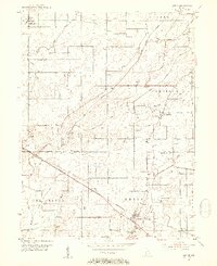
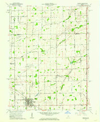
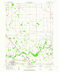
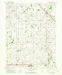
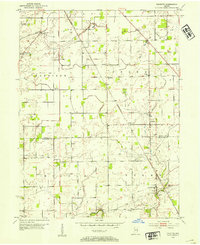 1953 Fayette1954 Print · USGSBoone County farm country is captured here in the early fifties, showing a landscape defined by small townships and traditional drainage. Genealogists can trace family names through numerous rural burial grounds like Mt Union Cem and Howard Cem.
 - 1953 Map of Rosston, 1954 Print
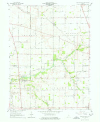
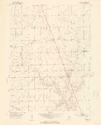 1953 Rosston1954 Print · USGSBoone County farm country is captured here in the early fifties, showing the rural communities and drainage networks of central Indiana. Genealogists can trace family landmarks like the Parr-Jones Cem, Antioch Ch, and the settlement at Big Springs.2 unique versions available
 - 1953 Map of Lizton, 1954 Print
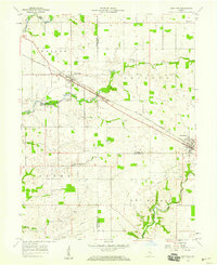
 1953 Lizton1954 Print · USGSMid-century Hendricks and Boone counties are captured here during a period of steady agricultural and rail activity. Genealogists can trace family roots through numerous local sites like the Cundiff Cemetery, Old Union Ch, and the New York Central corridor.2 unique versions available
 - 1953 Map of Zionsville, 1955 Print
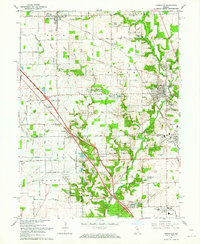
 1953 Zionsville1955 Print · USGSZionsville and its surrounding townships are caught in a moment of mid-century growth along the New York Central rail line. Genealogists and local historians can locate early landmarks like McCord Cem, Macedonia Ch, and the Wilson Scout Camp along the banks of Eagle Creek.
 - 1953 Map of Lebanon, 1955 Print
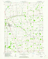
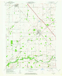
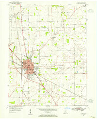 1953 Lebanon1955 Print · USGSThe Boone County seat thrives in the mid-1950s as a vital crossroads of the Pennsylvania and New York Central rail lines. Genealogists can locate family names at Oak Hill Cemetery or trace old school districts like Lindbergh Sch and Harney Sch.
 - 1953 Map of Danville, 1965 Print
 1953 Danville1965 Print · USGSIndiana and Illinois crossroads come to life in this mid-century survey as the interstate era begins to reshape the river-and-rail landscape. Genealogists and collectors can trace the historic paths of the Nickel Plate railroad or locate smaller communities like Veedersburg, Goodland, and Bismarck.3 unique versions available
 - 1953 Map of Indianapolis, 1965 Print
 1953 Indianapolis1965 Print · USGSCentral Indiana and the Illinois borderlands are captured in the mid-sixties, showing the growth of Indianapolis and its industrial rail corridors. Genealogists and historians can trace the development of outlying towns like Zionsville or Beech Grove and find landmarks such as Atterbury AAF and Turkey Run State Park.4 unique versions available
 - 1955 Map of Danville
 1955 Danville1955 Print · USGSThe Indiana-Illinois borderlands during the mid-fifties reveal a landscape of thriving rail hubs and university towns. Researchers can trace the legacy of Purdue University, the Tippecanoe Battlefield, and the path of the Pennsylvania RR.
 - 1956 Map of Danville
 1956 Danville1956 Print · USGSMid-century Indiana and Illinois are captured here as the river-and-rail economy evolved into the modern highway era. Researchers can trace ancestral roots and old transport lines through Logansport, Battle Ground, and the dams at Lake Shafer.
 - 1956 Map of Indianapolis
 1956 Indianapolis1956 Print · USGSCentral Indiana in the mid-fifties is captured during a period of industrial growth and military presence. Genealogists and historians can trace the rail networks of the New York Central or locate regional landmarks like Fort Benjamin Harrison and Camp Atterbury.
 - 1957 Map of Indianapolis
 1957 Indianapolis1957 Print · USGSCentral Indiana in the mid-fifties is captured here as a crossroads of major rail lines and nascent federal highways. Genealogists and historians can trace family-named ridges like Poplar Ridge or locate strategic sites like Camp Atterbury and Speedway.2 unique versions available
 - 1957 Map of New Ross, 1959 Print
 1957 New Ross1959 Print · USGSThe rail-and-river corridor of central Indiana comes to life in the late fifties, showing the agricultural networks between New Ross and Jamestown. Trace family history through landmarks like Mt Zion Ch and rural burial grounds including New Ross Cem.3 unique versions available
 - 1959 Map of Carmel, 1960 Print
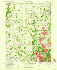 1959 Carmel1960 Print · USGSThe northern fringes of Indianapolis were rapidly transforming in the late fifties as subdivisions began to edge into the surrounding farmland. You can trace early neighborhood developments like Home Place and Meridian Hills alongside the Monon Railroad and the White River.
 - 1961 Map of Sheridan, 1962 Print
 1961 Sheridan1962 Print · USGSSheridan and the surrounding Indiana farm country are captured here at the start of the 1960s, showing a landscape defined by rail and early aviation. Researchers can trace the MONON line through town or locate family sites at Crown Hill Cem, Wiles Cem, and Hills Ch.3 unique versions available
 - 1961 Map of Mechanicsburg, 1962 Print
 1961 Mechanicsburg1962 Print · USGSMid-century Boone and Clinton County life is centered around the creek-side village of Mechanicsburg and the agricultural hub of Cyclone. Researchers can trace the path of the Monon Railroad or locate local landmarks like Bethel Ch and Garrett Cem.2 unique versions available
 - 1961 Map of Kirklin, 1963 Print
 1961 Kirklin1963 Print · USGSCentral Indiana farmland thrives in the early sixties, centered on the rail-linked village of Kirklin. Researchers can trace rural life through family-named landmarks like Bogan Cem, Sedwick Chapel, and the historic MONON railroad corridor.2 unique versions available
 - 1961 Map of Hazelrigg, 1963 Print
 1961 Hazelrigg1963 Print · USGSBoone County's agricultural and rail-oriented landscape is captured here in the early sixties, showing the vital connection between small towns and the New York Central Railroad. Genealogists and historians can locate family sites near Thorntown, Hazelrigg, and Dover, or trace landmarks like the Township Sch and Pleasant View Cem.2 unique versions available
 - 1961 Map of Shannondale, 1963 Print
 1961 Shannondale1963 Print · USGSCentral Indiana farm country comes into focus in the early sixties, showing the rural landscape before modern expansion. Genealogists can trace family roots through sites like Shannondale, Log Cabin Crossroads, and the Pisgah Cem.2 unique versions available
 - 1962 Map of Indianapolis
 1962 Indianapolis1962 Print · USGSCentral Indiana and the Illinois borderlands are captured here in the early sixties, showing the region's dense rail networks and growing urban centers. Genealogists and historians can locate family-named landmarks and institutions like Crown Hill Cem, Indiana University, and the Indianapolis Motor Speedway.
 - 1962 Map of Thorntown, 1963 Print
 1962 Thorntown1963 Print · USGSThorntown and the surrounding Boone County farmland are captured in the early sixties as a network of rail-side settlements and rural parishes. Genealogists and local historians can trace family-named landmarks like Maple Lawn Cem, Kinder Ch, and the Old Indian Treaty Boundary.3 unique versions available
 - 1962 Map of Colfax, 1963 Print
 1962 Colfax1963 Print · USGSColfax and the surrounding rural townships are shown here in the early sixties at a peak of mid-century rail activity. Genealogists can trace family connections through numerous local burial sites including Union Cem, Shilo Cem, and Plainview Cem near the banks of Sugar Creek.2 unique versions available
 - 1962 Map of Zionsville, 1964 Print
 1962 Zionsville1964 Print · USGSZionsville and the surrounding townships of Boone County are captured here in the early sixties as rural landscapes began to shift toward suburban life. Genealogists and local historians can trace family locations through numerous landmarks like McCord Cem, Salem Ch, and the settlement at Traders Point.
 - 1963 Map of Fayette, 1964 Print
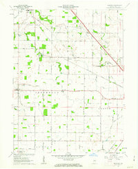
 1963 Fayette1964 Print · USGSThe rural borderlands of Boone and Hendricks counties are captured here in the early sixties, showing a landscape of family farms and small crossroad hamlets. Researchers can trace the heritage of Milledgeville and Fayette or locate ancestral sites like Bethesda Cem and Cynthiana Ch.
Showing maps 1-25 of 111
Top cities of Boone County
- Lebanon historical maps
- Zionsville historical maps
- Thorntown historical maps
- Jamestown historical maps
- Whitestown historical maps
- Advance historical maps
See more
Frequently asked questions
- What are the different types of historical maps available for Boone County?
- What is the oldest map of Boone County?
- Where can I purchase historical maps of Boone County for my home or office?
- Where can I download high-res historical maps of Boone County?
- Are there historical topographic maps available for Boone County?
- Is there historical aerial imagery available for Boone County?
- Where are historical maps of Boone County sourced from?